IMAGES TAKEN NEAR TO
Oxhey Road, WATFORD, WD19 4QE
Introduction
This page details the photographs taken nearby to Oxhey Road, WD19 4QE by members of the Geograph project.
The Geograph project started in 2005 with the aim of publishing, organising and preserving representative images for every square kilometre of Great Britain, Ireland and the Isle of Man.

There are currently over 7.5m images from over14,400 individuals and you can help contribute to the project by visiting https://www.geograph.org.uk
Image Map
Images are licensed for reuse under creativecommons.org/licenses/by-sa/2.0
Notes
- Clicking on the map will re-center to the selected point.
- The higher the marker number, the further away the image location is from the centre of the postcode.
Image Listing (9 Images Found)
Images are licensed for reuse under creativecommons.org/licenses/by-sa/2.0
Image
Details
Distance
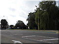
1
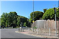
Oxhey Road at the junction of Eastbury Road
Image: © David Howard
Taken: 30 May 2021
0.05 miles
2
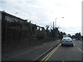
Eastbury Road at the junction of Deacons Hill
Image: © David Howard
Taken: 30 Aug 2012
0.05 miles
4
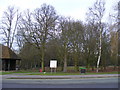
Oxhey Park
Taken from Eastbury Road (A4125)
Image: © PAUL FARMER
Taken: 31 Jan 2009
0.07 miles
5
Eastbury Road at the junction of Deacons Hill
Image: © David Howard
Taken: 30 Aug 2012
0.08 miles
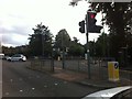
7
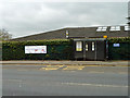
Long Croft bus stop
On Eastbury Road, this stop is for buses towards Watford.
Image: © Robin Webster
Taken: 10 Mar 2013
0.19 miles
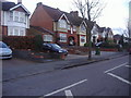
8

House on corner of Eastbury Road and Longcroft
Image: © Robin Webster
Taken: 10 Mar 2013
0.23 miles
9
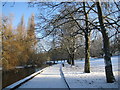
Oxhey Park
With the River Colne flowing downstream towards the photographer, kids were sledging down the hill to the right in the December snow of 2009.
Image: © Nigel Cox
Taken: 20 Dec 2009
0.25 miles