IMAGES TAKEN NEAR TO
Kingsfield Road, WATFORD, WD19 4PR
Introduction
This page details the photographs taken nearby to Kingsfield Road, WD19 4PR by members of the Geograph project.
The Geograph project started in 2005 with the aim of publishing, organising and preserving representative images for every square kilometre of Great Britain, Ireland and the Isle of Man.

There are currently over 7.5m images from over14,400 individuals and you can help contribute to the project by visiting https://www.geograph.org.uk
Image Map
Images are licensed for reuse under creativecommons.org/licenses/by-sa/2.0
Notes
- Clicking on the map will re-center to the selected point.
- The higher the marker number, the further away the image location is from the centre of the postcode.
Image Listing (24 Images Found)
Images are licensed for reuse under creativecommons.org/licenses/by-sa/2.0
Image
Details
Distance
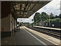
2
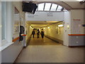
Tunnel to trains, Bushey & Oxhey station
Image: © David Howard
Taken: 14 Oct 2008
0.15 miles
3
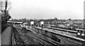
Bushey & Oxhey Station
Plain 'Bushey' since 5/74. View northward, towards Watford Junction; ex-London & North Western, West Coast Main line, also suburban (electrified) line to Watford Junction via Watford High St., which loops off here to the left and on which an LTE Bakerloo Line train from Elephant & Castle is seen. (The Underground services were cut back to Harrow & Wealdstone from 24/9/82).
Image: © Ben Brooksbank
Taken: 28 Jan 1962
0.15 miles
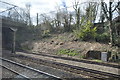
4
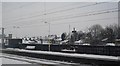
Passing through Bushey Station
On the West Coast Main Line.
Image: © N Chadwick
Taken: 19 Dec 2010
0.15 miles
5
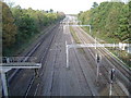
West Coast Main Line railway
Viewed looking northwards from the Oxhey Road footbridge towards Bushey station.
Image: © Nigel Cox
Taken: 12 Nov 2005
0.19 miles
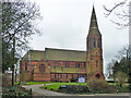
7
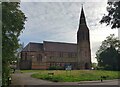
Oxhey: Church of St Matthew (2)
The church is a Grade II Listed Building, built of red brick in the Gothic style, and dating from 1880. This is the main north/north-western elevation, viewed from Eastbury Road.
Image: © Nigel Cox
Taken: 7 Oct 2020
0.19 miles
10
Oxhey parish church
St Matthew's is a grade II listed building, 1880.
Image: © Robin Webster
Taken: 10 Mar 2013
0.19 miles