IMAGES TAKEN NEAR TO
Eastbury Road, WATFORD, WD19 4PN
Introduction
This page details the photographs taken nearby to Eastbury Road, WD19 4PN by members of the Geograph project.
The Geograph project started in 2005 with the aim of publishing, organising and preserving representative images for every square kilometre of Great Britain, Ireland and the Isle of Man.

There are currently over 7.5m images from over14,400 individuals and you can help contribute to the project by visiting https://www.geograph.org.uk
Image Map
Images are licensed for reuse under creativecommons.org/licenses/by-sa/2.0
Notes
- Clicking on the map will re-center to the selected point.
- The higher the marker number, the further away the image location is from the centre of the postcode.
Image Listing (52 Images Found)
Images are licensed for reuse under creativecommons.org/licenses/by-sa/2.0
Image
Details
Distance
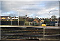
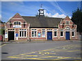
1
Bushey station, building on west side of railway
Similar to that on the east side. Most of the platforms are accessed by subway.
Image: © Robin Webster
Taken: 10 Mar 2013
0.03 miles
2
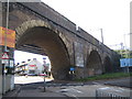
Bushey Arches
This well-known landmark is a five arched viaduct completed around 1835 to take the London to Birmingham Railway over the London Road. Only the central arch, on the left here, is skewed. The others, including the two out of the image to the left, are square on to the railway. The underside of the newer metal viaduct installed on the eastern side when the railway was widened is just visible. Today the A411 road passes eastbound through this skewed central arch but this is also a roundabout with traffic passing through the far arch too. The cost of the construction of the viaduct in the 1830s was £9,700. The buildings visible through the arch are on Chalk Hill.
Image: © Nigel Cox
Taken: 22 Jul 2007
0.03 miles
4
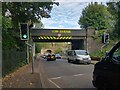
Oxhey: Eastbury Road railway bridge
The bridge carries what is now London Overground's railway line through Watford High Street station to Watford Junction over the A4125 Eastbury Road, just to the north of Bushey station.
The railway was a comparative latecomer, only being built by the then London & North Western Railway just before the start of the First World War.
One of the openings of Bushey Arches is visible through the bridge.
Image: © Nigel Cox
Taken: 7 Oct 2020
0.04 miles
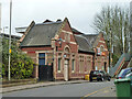
5
Bushey railway station
Bushey is a misnomer really because the station is in Oxhey, and the centre of Bushey is about a mile away. This is the eastern entrance and gratifyingly the ornate station clock with its train weathervane was telling the right time. During the ordinary working day Silverlink operate a half-hourly service to London Euston from here with a scheduled journey time of 19 minutes.
Image: © Nigel Cox
Taken: 22 Jul 2007
0.04 miles
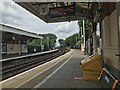
6
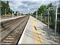
Bushey (& Oxhey) railway station, Hertfordshire
Opened in 1841 by the London & Birmingham Railway. View north on the main line platforms, with the local lines and platform (added in 1912) curving away on the left in the distance, on the loop line round to Watford High Street. Oxhey was included in the station name from 1912 to 1974.
Image: © Nigel Thompson
Taken: 3 Sep 2009
0.04 miles
7
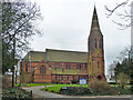
Oxhey parish church
St Matthew's is a grade II listed building, 1880.
Image: © Robin Webster
Taken: 10 Mar 2013
0.04 miles
8
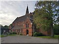
Oxhey: Church of St Matthew (1)
The church is a Grade II Listed Building, built of red brick in the Gothic style, and dating from 1880. This is the main south/south-eastern elevation.
Image: © Nigel Cox
Taken: 7 Oct 2020
0.04 miles
9
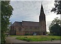
Oxhey: Church of St Matthew (2)
The church is a Grade II Listed Building, built of red brick in the Gothic style, and dating from 1880. This is the main north/north-western elevation, viewed from Eastbury Road.
Image: © Nigel Cox
Taken: 7 Oct 2020
0.05 miles