IMAGES TAKEN NEAR TO
Ascot Road, WATFORD, WD18 8AG
Introduction
This page details the photographs taken nearby to Ascot Road, WD18 8AG by members of the Geograph project.
The Geograph project started in 2005 with the aim of publishing, organising and preserving representative images for every square kilometre of Great Britain, Ireland and the Isle of Man.

There are currently over 7.5m images from over14,400 individuals and you can help contribute to the project by visiting https://www.geograph.org.uk
Image Map
Images are licensed for reuse under creativecommons.org/licenses/by-sa/2.0
Notes
- Clicking on the map will re-center to the selected point.
- The higher the marker number, the further away the image location is from the centre of the postcode.
Image Listing (80 Images Found)
Images are licensed for reuse under creativecommons.org/licenses/by-sa/2.0
Image
Details
Distance
1
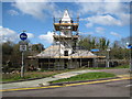
Watford: Sun Printers' Clock Tower
This little clock tower, built in 1934 off Ascot Road and currently being renovated, is the one of the few remaining artefacts of the once large Sun Printing works in West Watford. It was originally a water pumping station, built over an artesian well, and designed to provide a consistent flow of water to the printing works.
Image: © Nigel Cox
Taken: 21 Mar 2008
0.04 miles
2
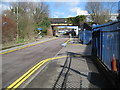
Watford: Ascot Road railway bridge
The bridge used to carry the Croxley Green branch line railway over Ascot Road. Image is just to the right of the bridge. Ascot Road is now a one-way road with traffic coming in this direction, although there is a cycleway on the far side of the road in the opposite direction.
Image: © Nigel Cox
Taken: 21 Mar 2008
0.04 miles
3
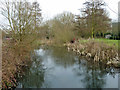
River Gade
Looking upstream from the Beggars Bush Lane bridge.
Image: © Robin Webster
Taken: 27 Mar 2013
0.05 miles
4

Disused bridge over Beggars Bush Lane
The former LNWR Croxley Green branch once crossed. There is a span over the Grand Union Canal to the left and this span also crosses the River Gade to the right.
Image: © Robin Webster
Taken: 27 Mar 2013
0.06 miles
5
Croxley Green railway bridge
This used to carry the Croxley Green branch of the London and North Western Railway, opened in 1912 and closed in 1996.
Image: © Graham Horn
Taken: 11 Apr 2010
0.06 miles
6

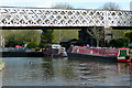
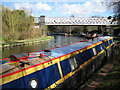
Grand Union Canal, Croxley Green
Winter sunshine gives a strong reflection of the narrowboats moored here at Cassio Wharf and of the bridge which carries the disused Croxley Green branch railway. The first of the boats is 'Asterope', originally built in 1935 as a cargo-carrying vessel but much modified since. Asterope, incidentally, is listed as a girl's name meaning lightning.
Image: © Stephen McKay
Taken: 12 Jan 2022
0.06 miles
7

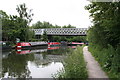
Grand Union Canal, Croxley Green
The bridge overhead carried the Watford - Croxley Green railway which has been disused since 1996.
Image: © Stephen McKay
Taken: 12 Jan 2022
0.06 miles
8
Grand Union Canal: Croxley Green railway viaduct
This viaduct used to carry the Croxley Green branch line over the Grand Union Canal, the River Gade, and Beggars Bush Lane, shortly before reaching its terminus station. The viaduct was built in 1912 by the London & North Western Railway. Train services were withdrawn in 1996 and the track is now cut back to Image This is the view in the opposite direction to Neil's Image
Image: © Nigel Cox
Taken: 21 Mar 2008
0.06 miles
9
ex-LNWR viaduct over Grand Union Canal
This viaduct formerly carried the branch line from Watford Junction to Croxley Green. However, this line was 'temporarily' closed some years ago, and was severed by a road. Since both the terminal station at Croxley Green and the intermediate one at Watford West have both now been removed, it seems highly unlikely that the branch will ever re-open.
Image: © Dr Neil Clifton
Taken: 12 Jun 2007
0.06 miles
10
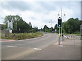
Croxley Rail Link (4): Ascot Road
In July 2013 The Secretary of State for Transport issued a Transport and Works Act Order for the proposed Croxley Rail Link scheme granting the planning permissions, access rights and land transfers necessary for the scheme to go ahead. The £118m scheme proposes that the current London Underground Metropolitan Line branch to Watford would be re-routed from a point east of Croxley station and extended to Watford Junction station via Watford High Street station, with the closure of the original Watford station to passenger traffic. It is proposed that new stations would be provided on the new rail link at Ascot Road, where a park and ride facility would be provided, and at Vicarage Road, in order to serve Watford General Hospital, the proposed Watford Health Campus development, and Watford Football Club. Construction work is scheduled to commence in 2014 with completion planned for 2016. The Croxley Rail Link's website is here http://www.croxleyraillink.com/Default.htm
This is the area where it is proposed that the new viaduct from the existing Metropolitan Line would cross the dual carriageway part of Ascot Road. The site of the proposed Ascot Road station would be in the scrubby trees on the left side of the road. The former L&NWR line to Croxley Green station used to cross the route of the dual carriageway on an embankment here that was removed when the dual carriageway was built.
Image is visible on the left.
Image: © Nigel Cox
Taken: 4 Aug 2013
0.06 miles