IMAGES TAKEN NEAR TO
Mildred Avenue, WATFORD, WD18 7DZ
Introduction
This page details the photographs taken nearby to Mildred Avenue, WD18 7DZ by members of the Geograph project.
The Geograph project started in 2005 with the aim of publishing, organising and preserving representative images for every square kilometre of Great Britain, Ireland and the Isle of Man.

There are currently over 7.5m images from over14,400 individuals and you can help contribute to the project by visiting https://www.geograph.org.uk
Image Map
Images are licensed for reuse under creativecommons.org/licenses/by-sa/2.0
Notes
- Clicking on the map will re-center to the selected point.
- The higher the marker number, the further away the image location is from the centre of the postcode.
Image Listing (23 Images Found)
Images are licensed for reuse under creativecommons.org/licenses/by-sa/2.0
Image
Details
Distance
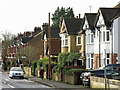
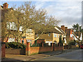
2

Rickmansworth Road at the junction of Cassiobury Park Avenue
Image: © David Howard
Taken: 6 Sep 2012
0.08 miles
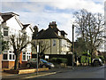
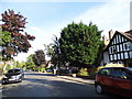
4
Cassiobury Park Avenue / Rickmansworth Road
Image: © Mike Quinn
Taken: 15 Jan 2020
0.11 miles
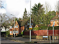
8
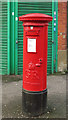
George V postbox, Whippendell Road / Park Avenue
The location of this postbox is shown in Image
Image: © Mike Quinn
Taken: 15 Jan 2020
0.14 miles
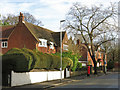
9

George V postbox, Whippendell Road / Park Avenue - royal cipher
See Image
Image: © Mike Quinn
Taken: 15 Jan 2020
0.14 miles
10

George V postbox, Whippendell Road / Park Avenue - aperture and collection plate
See Image
Image: © Mike Quinn
Taken: 15 Jan 2020
0.14 miles