IMAGES TAKEN NEAR TO
Tolpits Lane, WATFORD, WD18 6NT
Introduction
This page details the photographs taken nearby to Tolpits Lane, WD18 6NT by members of the Geograph project.
The Geograph project started in 2005 with the aim of publishing, organising and preserving representative images for every square kilometre of Great Britain, Ireland and the Isle of Man.

There are currently over 7.5m images from over14,400 individuals and you can help contribute to the project by visiting https://www.geograph.org.uk
Image Map
Images are licensed for reuse under creativecommons.org/licenses/by-sa/2.0
Notes
- Clicking on the map will re-center to the selected point.
- The higher the marker number, the further away the image location is from the centre of the postcode.
Image Listing (33 Images Found)
Images are licensed for reuse under creativecommons.org/licenses/by-sa/2.0
Image
Details
Distance
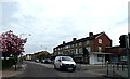
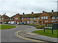
3
Watford: Tolpits Lane
This housing was built in the 1990s on the site of the former Scammell lorry factory on Tolpits Lane. The road through the estate is Scammell Way which runs between the two white faced buildings. The Scammell factory existed on the site between 1922 and 1988.
Image: © Nigel Cox
Taken: 28 May 2006
0.06 miles
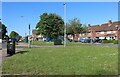
4
Flats on Tolpits Lane, Holywell
At the junction of Croxley View
Image: © David Howard
Taken: 11 Dec 2014
0.12 miles
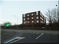
6
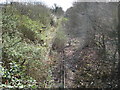
Watford West railway station (disused)
Nearly three years on from Hywel's Image and about the only changes are that the scrubby vegetation has grown thicker and the red box containing the train driver's mirror has disappeared. The tracks sleepers and electrified third rail remain in situ... This was taken from the Tolpits Lane road bridge. See Image for a view of the outside of the station.
Image: © Nigel Cox
Taken: 21 Mar 2008
0.15 miles

8

Holy Rood Church Hall and Social Centre
On Tolpits Lane.
Image: © Robin Webster
Taken: 10 Mar 2013
0.15 miles
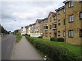
10
Tolpits Lane, Holywell
Holywell School is opposite behind the fence
Image: © David Howard
Taken: 11 Dec 2014
0.18 miles