IMAGES TAKEN NEAR TO
Tolpits Lane, WATFORD, WD18 6NS
Introduction
This page details the photographs taken nearby to Tolpits Lane, WD18 6NS by members of the Geograph project.
The Geograph project started in 2005 with the aim of publishing, organising and preserving representative images for every square kilometre of Great Britain, Ireland and the Isle of Man.

There are currently over 7.5m images from over14,400 individuals and you can help contribute to the project by visiting https://www.geograph.org.uk
Image Map
Images are licensed for reuse under creativecommons.org/licenses/by-sa/2.0
Notes
- Clicking on the map will re-center to the selected point.
- The higher the marker number, the further away the image location is from the centre of the postcode.
Image Listing (40 Images Found)
Images are licensed for reuse under creativecommons.org/licenses/by-sa/2.0
Image
Details
Distance
1
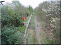
Watford West disused station
This is Watford West station - disused since 1996. The station was left to decay - it even has signs in place on the street level at the time the photograph was taken 9 years after it closed. The driver mirrors can clearly be seen.
Image: © Hywel Williams
Taken: 16 Apr 2005
0.13 miles
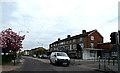
2

Holy Rood Church Hall and Social Centre
On Tolpits Lane.
Image: © Robin Webster
Taken: 10 Mar 2013
0.13 miles
3
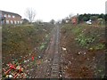
Croxley Rail Link (14): Trackbed north-west of the former Watford West Station
For many years this view of the former L&NWR's Croxley Branch, from the Tolpits Lane road bridge, was completely obscured by a wall of tree vegetation. However all the trackside vegetation has now been removed in preparation for the development of the link, which is now formally known as the Metropolitan Line Extension. Unlike in other locations along the disused route the electrified third rail that powered trains in the last days of its Network Rail use is still largely in place, although hopefully turned off...
Image: © Nigel Cox
Taken: 13 Dec 2015
0.13 miles
4
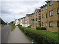
Watford: Tolpits Lane
This housing was built in the 1990s on the site of the former Scammell lorry factory on Tolpits Lane. The road through the estate is Scammell Way which runs between the two white faced buildings. The Scammell factory existed on the site between 1922 and 1988.
Image: © Nigel Cox
Taken: 28 May 2006
0.14 miles

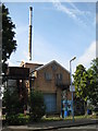
6
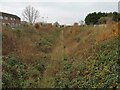
Croxley Rail Link (18): Trackbed north-west of the former Watford West Station
Five years on from Image] and amidst funding disputes that have caused the project to stall, vegetation is again taking over the proposed rail link, although the track remains extant.
Image: © Nigel Cox
Taken: 24 Nov 2020
0.15 miles
7
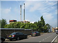
Watford Laundry (1)
There has been a laundry on this site in Sydney Road since before 1914, as that is the date of the first Ordnance Survey 1:2,500 scale maps to show one. Please see Image for another view.
Image: © Nigel Cox
Taken: 28 Jun 2009
0.15 miles
9
Watford Laundry (2)
There has been a laundry on this site in Sydney Road since before 1914, as that is the date of the first Ordnance Survey 1:2,500 scale maps to show one. Please see Image for another view.
Image: © Nigel Cox
Taken: 28 Jun 2009
0.15 miles
10

The Laundry Works development, Watford
As the name implies there was previously a commercial laundry on this site on Sydney Road. It is now being developed by Weston Homes who are building 1, 2 and 3 bedroom apartments and penthouses. There will be eight separate 'architecturally distinctive' buildings.
Image: © Stephen McKay
Taken: 12 Jan 2022
0.16 miles