IMAGES TAKEN NEAR TO
Thomas Sawyer Way, WATFORD, WD18 0GS
Introduction
This page details the photographs taken nearby to Thomas Sawyer Way, WD18 0GS by members of the Geograph project.
The Geograph project started in 2005 with the aim of publishing, organising and preserving representative images for every square kilometre of Great Britain, Ireland and the Isle of Man.

There are currently over 7.5m images from over14,400 individuals and you can help contribute to the project by visiting https://www.geograph.org.uk
Image Map
Images are licensed for reuse under creativecommons.org/licenses/by-sa/2.0
Notes
- Clicking on the map will re-center to the selected point.
- The higher the marker number, the further away the image location is from the centre of the postcode.
Image Listing (22 Images Found)
Images are licensed for reuse under creativecommons.org/licenses/by-sa/2.0
Image
Details
Distance
1
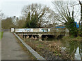
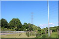
A4178 Wiggenhall Road bridge over River Colne
Looking downstream.
Image: © Robin Webster
Taken: 10 Mar 2013
0.09 miles
2
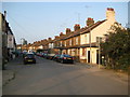
Watford: Cardiff Road
These terraced houses almost certainly date from around the Edwardian period as they are not shown on the Ordnance Survey's map of 1899 but are shown on the 1920 edition. This area of Watford is known as Colney Butts. To pinpoint the time that this photograph was taken it coincided precisely with the roar that went up from nearby Image when John Eustace scored a 59th minute equalizer for Watford against Ipswich Town. Watford went on to win 2-1.
Image: © Nigel Cox
Taken: 30 Aug 2008
0.10 miles
3
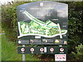
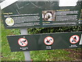
Information Board at west end of Oxhey Park
This information board erected by Watford Borough Council, is by the River Colne in Wiggenhall Road. It shows a map of the park with the following wording above it:
Welcome to Oxhey Park
Points of Interest (in blue)
1) River Colne
2) The Dell
3) The Terrace
4) Grand Steps
5) Art Piece (Conker Sculpture)
6) Art Piece (Carved Oak Seat)
Facilities (in red)
1) Children's Play Area
2) 'Kick About' Area
3) Cycle Route
4) Seating Areas
5) Outdoor Gym
6) Picnic Area
Below the map is detailed information on
i) Oxhey Park
ii) How Oxhey Park came to be
iii) Places of interest
iv) Oxhey Park Refurbishment
v) Art in the Park
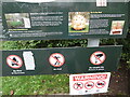
Below that detailed information panel is a panel with the
following road signs from left to right:
i) No Dropping Litter
ii) No Dog Fouling
iii) No Fires or Barbecues
iv) No Golf
v) Do not pick the flowers or plants
There is another identical information board at the east end of Oxhey Park near
Bushey Arches, and two similar boards at the entrances to Oxhey Park in
Eastbury Road.
Image: © David Hillas
Taken: 22 Oct 2021
0.10 miles
4
Detailed Information on the Information Board at Oxhey Park (2)
This photo shows detailed information below the map on the information board in Wiggenhall Road. It has the following wording:
Places of interest
The Dell is a densely wooded area with steep banks falling away from the
Eastbury Road down to the River Colne. Its distinct woodland character provides
an ideal home for a variety of wildlife. Built in 1912, the magnificent LMS
Bushey Viaduct or Bushey Curve contributes to the setting of the Park and in
particular The Dell.
The River Colne Walk is a tree-lined riverside footpath running from the
Wiggenhall Road entrance in the west through to the Viaduct. This area provides
a natural habitat for a variety of wildlife.
The Colne Viaduct or Bushey Arches were built by Robert Stephenson, a
nationally renowned bridge builder, and son of the famous railways and colliery
engineer George Stephenson.
Image of the River Colne Walk
Oxhey Park Refurbishment
Oxhey park has undergone a major refurbishment programme.
Led by Southern Green Landscape Architects working alongside Watford Borough
Council and the Friends of Oxhey Park, the project has incorporated new
footpaths, improved park furniture, seating and planting areas, enhanced focal
points and facilities, as well as the introduction to two pieces of public
artwork.
Art in the Park
Using natural materials and reflecting the character of the Park itself,
sculptor David Gross has created two beautiful pieces of art for everyone to
enjoy.
Located at the top of the Grand Steps and inspired by the surrounding avenue of
horse chestnut trees, the first piece is a 2.5m high conker sculpture. Made
from green oak, the smooth seed appears to be bursting out of its spiky shell
symbolising the re-birth and new beginnings of the Park.
The second piece is an original oak seat overlooking the conker sculpture.
Carved in a series of arches, the solid base reflects the Bushey Arches and
Bushey Viaduct or "Curve" running through the Park, whilst the back rest takes
the form of a folded horse chestnut leaf.
Images of the conker and oak seat sculptures.
Image: © David Hillas
Taken: 22 Oct 2021
0.10 miles
6
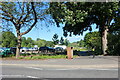
Oxhey Park
Looking towards the car park
Image: © David Howard
Taken: 30 May 2021
0.11 miles
7
Detailed Information on the Information Board at Oxhey Park (1)
This photo shows detailed information below the map on the Information Board in
Wiggenhall Road. It has the following wording:
Oxhey Park
Oxhey Park is situated on land originally part of the Wiggen Hall Estate, with
a history which goes back hundreds of years.
In the 15th Century the manor of Wiggenhall cum Oxhey was owned by St Alban's
Abbey (now Cathedral). After the dissolution of the Church during the reign of
Henry VIII the land then passed to private ownership. During the 16th and 17th
Centuries Sir William Bucknall and his heirs owned the Oxhey/Wiggen Hall Estate
(living at Oxhey Place). Wiggen Hall Manor was leased to the Deacon family who
lived there until the mid-19th Century. In 1826 Wiggen Hall and the Estate were
bought by Jonathon King passing to his nephew Joseph Gutteridge Smith in 1881.
Ordnance Survey records from the 1870s show the Wiggen Hall as a large country
house overlooking the River Colne, with elaborate gardens, a walled garden,
woodland pleasure grounds and landscaped parklands. During World War I a large
proportion of the land was requisitioned for food production. By 1929 Wiggen
Hall was unoccupied and then eventually demolished in 1955.
How Oxhey Park came to be
In 1920 Watford Borough Council (with help from a Government Grant) bought 85
acres of the Estate for £14,000 in order that they could build a housing
development and provide recreational space for the local community.
In January 1924 the Estates Committee at the Council recommended that the newly
allocated public park be known as Oxhey Park. In the 1920s, as now, a walk
along the river was one of the main attractions of the park. By the 1930s
refreshments were being sold from a boathouse to the north of the River Colne
and fishing, boating and swimming were all allowed. The first children's
playground was built in 1930.
The two images show the Colne Viaduct or Bushey Arches.
Image: © David Hillas
Taken: 22 Oct 2021
0.11 miles
8
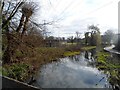
The River Colne, Watford
Taken from the road bridge (A4178) facing eastwards.
Image: © Bikeboy
Taken: 23 Mar 2014
0.13 miles
9
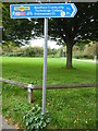
Blue Signpost by Riverside Park
This signpost is by Riverside Park and points towards Westfield Community Technology College (TQ0995) 1¼ miles and Rickmansworth (TQ0694) 3½ miles. It also indicates The Ebury Way foot and cycle path, and national cycle routes 6 (London to Lake District) and 61 (Maidenhead to Hoddesdon). For SatNav purposes, the postcode of this signpost is WD19 4HU.
Image: © David Hillas
Taken: 22 Oct 2021
0.13 miles
10
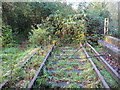
Watford: Former Croxley Green branch line railway
The buddleia grows ever denser on the trackbed of this disused railway line, abandoned to nature 12 years before this photograph was taken.
The railway originally formed part of the Watford to Rickmansworth line, opened in 1862, and shortly afterwards taken over by the London & North Western Railway (LNWR). In 1912 the LNWR opened a further branch line to Croxley Green, diverting from the original Rickmansworth branch about 100 metres into what is now the jungle. In 1952 the original Rickmansworth branch was closed, but the Croxley Green branch survived until 1996.
The Croxley Green branch was powered by an electrified third rail, seen on the right side of the running rails in this photograph. This electrification method was, and is, used throughout the suburban network of the former Southern Railway, but its use was very unusual this far north.
Image: © Nigel Cox
Taken: 21 Oct 2008
0.13 miles