IMAGES TAKEN NEAR TO
Smith Street, WATFORD, WD18 0GQ
Introduction
This page details the photographs taken nearby to Smith Street, WD18 0GQ by members of the Geograph project.
The Geograph project started in 2005 with the aim of publishing, organising and preserving representative images for every square kilometre of Great Britain, Ireland and the Isle of Man.

There are currently over 7.5m images from over14,400 individuals and you can help contribute to the project by visiting https://www.geograph.org.uk
Image Map
Images are licensed for reuse under creativecommons.org/licenses/by-sa/2.0
Notes
- Clicking on the map will re-center to the selected point.
- The higher the marker number, the further away the image location is from the centre of the postcode.
Image Listing (171 Images Found)
Images are licensed for reuse under creativecommons.org/licenses/by-sa/2.0
Image
Details
Distance
1
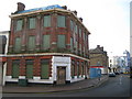
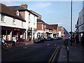
Watford: Former Barclays Bank
You can just about pick out the words Barclays Bank in the grubby fascia above the ground floor level, and the word Bank carved in the stone lintel above the entrance on the corner of this attractive and historic building, which is at the junction of the High Street to the left and King Street to the right. There are plans to redevelop this whole block stretching down to Image in the distance. To be known as the Met Quarter the redevelopment would have both residential and commercial uses. However this building is not statutorily listed and was under threat of demolition during this redevelopment, until, for once, Watford Borough Council acknowledged its duty to preserve what little remains of historic buildings in the town, and stepped in to demand its retention. The most recent plans appear to be to still demolish the bank but to incorporate the retention of its façade into the new scheme.
After Barclays vacated the building it may have been used as a pub or some other type of similar outlet.
Image: © Nigel Cox
Taken: 16 Feb 2008
0.01 miles
3

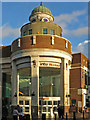
Watford: Former Mecca Bingo Hall
Mecca closed this facility (?) in King Street in November 2014, after about 46 years of use as a bingo hall, citing dwindling customers as the reason. The purple sign tells disappointed punters that the nearest other Meccas are in Luton and Hayes. Please see Image for a history of this building which started out in life as a cinema.
There are plans to build 25 flats and a retail outlet on the site, necessitating the demolition of much of the back of the building but retaining the Art Deco front facade.
Image: © Nigel Cox
Taken: 22 Mar 2015
0.03 miles
4
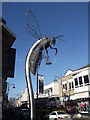
Watford Hornet sculpture
This metal sculpture is at the junction of Watford High Street (on the right) and King Street. The sculpture is a reference to the nickname of the local football team.
Image: © David Anstiss
Taken: 27 Jan 2013
0.04 miles
5
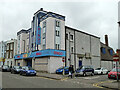
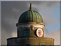
Mecca Bingo, Watford
Formerly the Essoldo cinema, later flats, retaining the facade.
Image: © Robin Webster
Taken: 10 Mar 2013
0.04 miles
7
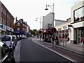
into intu
Shows the location of Image
intu has "20 centres across the UK and Spain" and its "whole business is focused on creating the best places for shopping and leisure, so that visitors come more often and stay longer. [intu] do that by bringing together [their] scale, expertise and understanding of what visitors want to provide compelling experiences that deliver real results for [their] customers, restaurateurs and leisure specialists". I did not make that up - see https://www.intugroup.co.uk/en/ .
Update March 2020: Perhaps the customer experiences aren't quite as "compelling" as intu was boasting: the company recently posted a loss of £2 billion for 2019 and may collapse https://www.theguardian.com/business/2020/mar/12/intu-warns-it-could-go-bust-after-reporting-2bn-loss .
Image: © Mike Quinn
Taken: 15 Jan 2020
0.04 miles
10
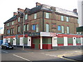
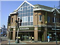
Watford: Former police station and former public house
This building, on the corner of King Street to the left, and Smith Street to the right, dates from 1888 and was Watford's police station until 1962. In that year the new police station was opened in Shady Lane and this building was converted into a public house, called, unsurprisingly, the Sir Robert Peel, and remained as such until very recently.
A comparison with a wood etching of the building made when it was newly constructed reveals that a few things have changed. The ground floor level facings over the original brickwork came with the conversion, as did the loss of the ground floor level corner, and a couple of chimneys have been demolished, including the obvious one above the chimney breast with the terracotta date tablet, which was quite high.
The whole block, including Image is earmarked for residential and commercial development as the Met Quarter, and as part of the plans the building was to be demolished. However in June 2007 Watford Borough Council for once sought to preserve what little remains of the town's historic buildings, and refused to uphold the demolition on the grounds that it would have a detrimental impact on the streetscape and on the character and appearance of the conservation area.
Image: © Nigel Cox
Taken: 16 Feb 2008
0.05 miles