IMAGES TAKEN NEAR TO
Fisher Industrial Estate, Wiggenhall Road, WATFORD, WD18 0FE
Introduction
This page details the photographs taken nearby to Fisher Industrial Estate, Wiggenhall Road, WD18 0FE by members of the Geograph project.
The Geograph project started in 2005 with the aim of publishing, organising and preserving representative images for every square kilometre of Great Britain, Ireland and the Isle of Man.

There are currently over 7.5m images from over14,400 individuals and you can help contribute to the project by visiting https://www.geograph.org.uk
Image Map
Images are licensed for reuse under creativecommons.org/licenses/by-sa/2.0
Notes
- Clicking on the map will re-center to the selected point.
- The higher the marker number, the further away the image location is from the centre of the postcode.
Image Listing (23 Images Found)
Images are licensed for reuse under creativecommons.org/licenses/by-sa/2.0
Image
Details
Distance
1
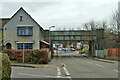
Railway bridge CWJ/61 over Lammas Road, Watford
The DC electric loop through Watford High Street crosses.
Image: © Robin Webster
Taken: 10 Mar 2013
0.06 miles
2
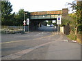
Watford: Lammas Road railway bridge
The railway from Watford to Rickmansworth (Church Street) through Watford High Street station was originally opened in 1862 and subsequently taken over in 1881 by the London & North Western Railway (LNWR). However it was not until some fifty years later, and just before the start of the First World War, that the LNWR built the connecting lines between Bushey and Watford High Street stations and between Bushey and Rickmansworth (Church Street) stations, creating a triangular junction in the process. This bridge carries the last surviving section of these railways and the junction, between Bushey and Watford High Street stations, over Lammas Road.
The No Waiting road signs define the parking restrictions in place whenever the Watford Stadium at Vicarage Road is in use for match days.
Image: © Nigel Cox
Taken: 30 Aug 2008
0.06 miles
3
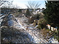
Watford: Disused railway to Croxley Green
Thirteen years after its closure in 1996 and the trackwork of the Croxley Green branch line from Watford High Street station is still in situ, just visible in the snow bottom right in this view taken from the Wiggenhall Road bridge. There has been a railway here since 1862 when the branch line from Watford Junction to Rickmansworth was built. Around fifty years later the London & North Western Railway built a branch line off the Rickmansworth line to Croxley Green. Forty years after that, in 1952, the Rickmansworth branch was closed to passenger traffic, and in 1967 freight services ceased too, and the track was cut back to the junction with the Croxley Green branch.
Image: © Nigel Cox
Taken: 20 Dec 2009
0.08 miles
5
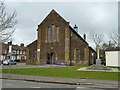
Former St James's church and war memorial, Watford Fields
Image: © Robin Webster
Taken: 10 Mar 2013
0.10 miles
6
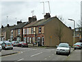
Watford: Cardiff Road
These terraced houses almost certainly date from around the Edwardian period as they are not shown on the Ordnance Survey's map of 1899 but are shown on the 1920 edition. This area of Watford is known as Colney Butts. To pinpoint the time that this photograph was taken it coincided precisely with the roar that went up from nearby Image when John Eustace scored a 59th minute equalizer for Watford against Ipswich Town. Watford went on to win 2-1.
Image: © Nigel Cox
Taken: 30 Aug 2008
0.10 miles
7
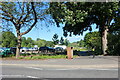
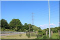
Oxhey Park
Looking towards the car park
Image: © David Howard
Taken: 30 May 2021
0.10 miles
8
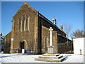
Watford Fields: The War Memorial
Located outside the former Church of St James each panel of the War Memorial records the names of about twenty men who gave their lives in the First World War. This is an extraordinary number when you consider the comparatively small size of the neighbourhood of terraced houses that would have existed at that time.
Image: © Nigel Cox
Taken: 20 Dec 2009
0.10 miles
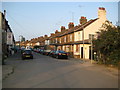
9
Houses on Cannon Road, Watford Fields
The street name is likely to be related to the Cannon Brewery of Benskin's that was formerly nearby. I suspect that the whole settlement of Watford Fields was built for the workforce.
Image: © Robin Webster
Taken: 10 Mar 2013
0.11 miles
10
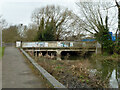
A4178 Wiggenhall Road bridge over River Colne
Looking downstream.
Image: © Robin Webster
Taken: 10 Mar 2013
0.11 miles