IMAGES TAKEN NEAR TO
George Street, WATFORD, WD18 0BX
Introduction
This page details the photographs taken nearby to George Street, WD18 0BX by members of the Geograph project.
The Geograph project started in 2005 with the aim of publishing, organising and preserving representative images for every square kilometre of Great Britain, Ireland and the Isle of Man.

There are currently over 7.5m images from over14,400 individuals and you can help contribute to the project by visiting https://www.geograph.org.uk
Image Map
Images are licensed for reuse under creativecommons.org/licenses/by-sa/2.0
Notes
- Clicking on the map will re-center to the selected point.
- The higher the marker number, the further away the image location is from the centre of the postcode.
Image Listing (191 Images Found)
Images are licensed for reuse under creativecommons.org/licenses/by-sa/2.0
Image
Details
Distance
1
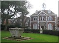
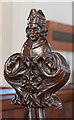
Watford: Elizabeth Fuller's Free School
Elizabeth Fuller (1644–1709), often called Dame Elizabeth Fuller as a title of respect, founded her Free School for forty boys and twenty girls in grounds next to the churchyard of St Mary in 1704. The School eventually developed into the separate Watford Girls' and Boys' Grammar Schools.
The building is Grade II* Listed and the Historic England website describes it thus:-
"1704 school building. Brick with red brick and stone dressings. Two storeys and attic. Plain tile hipped roof surmounted by 6 sided cupola with lead dome. Two hipped dormers. Regular front. Three window range. Centre breaks forward with pediment. Wood dentil eaves cornice. Stone quoins to centre bay and outer angles. Stone band across. Stone central doorcase with moulded architrave and enriched segmental pediment on brackets. Inscription to Mrs Fuller in broad frieze below. Ten panel double doors. Large round-headed windows with gauged brick arches, wooden Y-tracery and leaded lights. Oval keyed window in pediment with ornamental stucco scroll beneath with MDCCIV in raised letters."
On the left is the Grade II Listed Dalton/Guest tomb in the church graveyard.
Image: © Nigel Cox
Taken: 22 Mar 2015
0.00 miles
2
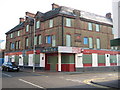
Watford: Former police station and former public house
This building, on the corner of King Street to the left, and Smith Street to the right, dates from 1888 and was Watford's police station until 1962. In that year the new police station was opened in Shady Lane and this building was converted into a public house, called, unsurprisingly, the Sir Robert Peel, and remained as such until very recently.
A comparison with a wood etching of the building made when it was newly constructed reveals that a few things have changed. The ground floor level facings over the original brickwork came with the conversion, as did the loss of the ground floor level corner, and a couple of chimneys have been demolished, including the obvious one above the chimney breast with the terracotta date tablet, which was quite high.
The whole block, including Image is earmarked for residential and commercial development as the Met Quarter, and as part of the plans the building was to be demolished. However in June 2007 Watford Borough Council for once sought to preserve what little remains of the town's historic buildings, and refused to uphold the demolition on the grounds that it would have a detrimental impact on the streetscape and on the character and appearance of the conservation area.
Image: © Nigel Cox
Taken: 16 Feb 2008
0.02 miles
3
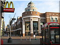
Watford: The Harlequin Centre
This is the main High Street entrance to the covered Harlequin Centre shopping precinct. This now contains most of Watford's town centre chain stores and shops. The dome is a familiar landmark to generations as it was retained from the building that was here previously, Ketts the electrical retailers. The street leading away to the left of the entrance is Queens Road, and the junction with the High Street and the building were generally known as Ketts Corner.
The sculpture is of a hornet after the nickname of Watford FC.
I am given to understand that the corporate logo on the building on the left indicates that this is some kind of eating establishment.
Image: © Nigel Cox
Taken: 16 Feb 2008
0.02 miles
6
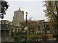
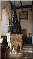
St Mary's Church, Watford
Some parts of the church date back to around 1230, with several extensions built and refurbishments completed since then. Today there is also an adjoining Church Centre, constructed in the late 1970s.
Image: © Richard Rogerson
Taken: 20 Oct 2015
0.04 miles
7
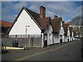
Watford: Bedford Almshouses
This row of 8 almshouses in Church Street dates from 1580 and is Grade II Listed. The Historic England website describes them thus:-
"Bedford and Essex Almshouses (Numbers 1 to 8 consecutive), formerly listed as The Lord Essex Almshouses.
1580 row of 8 almshouse cottages. Rendered, one storey and attic. Plain tile roofs with 4 massive paired brick chimney stacks. Regular front of 3 big gables and 2 smaller end gables. Overhanging eaves. Wood mullioned windows, 4-light in large gables, 2-light in end gables and ground floor. Simply moulded door openings, paired in central 3 sections. Queen strut roof trusses with straight bracing. Built by Francis, 2nd Earl of Bedford to house 8 poor women from Watford, Chenies and Langley."
Please see Image for a similar view in 2006.
Image: © Nigel Cox
Taken: 22 Mar 2015
0.04 miles
10
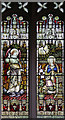
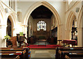
St Mary, Watford - Stained glass window
Image: © John Salmon
Taken: 26 Feb 2016
0.04 miles