IMAGES TAKEN NEAR TO
Hawthorn Close, WATFORD, WD17 4SB
Introduction
This page details the photographs taken nearby to Hawthorn Close, WD17 4SB by members of the Geograph project.
The Geograph project started in 2005 with the aim of publishing, organising and preserving representative images for every square kilometre of Great Britain, Ireland and the Isle of Man.

There are currently over 7.5m images from over14,400 individuals and you can help contribute to the project by visiting https://www.geograph.org.uk
Image Map (Loading...)


Getting Data...Please wait
Leaflet Map data © OpenStreetMap
Images are licensed for reuse under creativecommons.org/licenses/by-sa/2.0
Notes
- Clicking on the map will re-center to the selected point.
- The higher the marker number, the further away the image location is from the centre of the postcode.
Image Listing (15 Images Found)
Images are licensed for reuse under creativecommons.org/licenses/by-sa/2.0
Image
Details
Distance
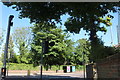
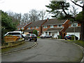
1
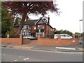
Nascot Wood Road, Watford
Part of the leafy suburbs to the north west of Watford town centre.
Image: © Stephen McKay
Taken: 30 Jan 2016
0.06 miles
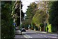
3
Nascott Wood Road meets Langley Road, Watford
Image: © Robin Webster
Taken: 10 Mar 2013
0.12 miles
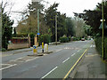
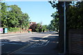
4

Hempstead Road at the junction of Langley Way
Image: © David Howard
Taken: 28 May 2020
0.13 miles
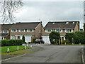
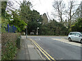
8
Molteno Road, Watford
Off Langley Road.
Image: © Robin Webster
Taken: 10 Mar 2013
0.18 miles
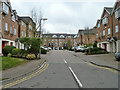
9
Houses on Bay Tree Walk
A dead end round the corner. On a quest for a continuation on foot, but it was not to be.
Image: © Robin Webster
Taken: 10 Mar 2013
0.19 miles