IMAGES TAKEN NEAR TO
Stratford Road, WATFORD, WD17 4PA
Introduction
This page details the photographs taken nearby to Stratford Road, WD17 4PA by members of the Geograph project.
The Geograph project started in 2005 with the aim of publishing, organising and preserving representative images for every square kilometre of Great Britain, Ireland and the Isle of Man.

There are currently over 7.5m images from over14,400 individuals and you can help contribute to the project by visiting https://www.geograph.org.uk
Image Map
Images are licensed for reuse under creativecommons.org/licenses/by-sa/2.0
Notes
- Clicking on the map will re-center to the selected point.
- The higher the marker number, the further away the image location is from the centre of the postcode.
Image Listing (17 Images Found)
Images are licensed for reuse under creativecommons.org/licenses/by-sa/2.0
Image
Details
Distance
1
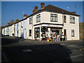
Watford: Langley Hardware, 32 Langley Road
In these days of dominance by a few large d-i-y chain stores it is heartening to see that the traditional hardware store is still thriving. On display outside the shop today there is a mop head for every occasion, brushes, all sorts of shapes and sizes of galvanized dustbins, even a zinc bath! So, good people of Watford, get down there today and support your local store!
Image: © Nigel Cox
Taken: 16 Feb 2008
0.11 miles
2
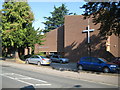
Watford: St Thomas' United Reformed Church
The church is in Langley Road.
The United Reformed Church was formed as the result of a union between the Presbyterian Church of England and the Congregational Church in England and Wales in 1972, and subsequent unions with the Reformed Association of Churches of Christ in 1981 and the Congregational Union of Scotland in 2000.
Image: © Nigel Cox
Taken: 21 Sep 2008
0.11 miles
3
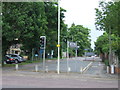
Stratford Road, Watford
Stratford Road at its junction with Hempstead Road. The road has been blocked off at this junction to prevent through traffic from using it.
Image: © Malc McDonald
Taken: 23 Jun 2012
0.11 miles
4
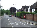
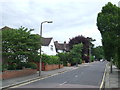
Stratford Way, Watford
Stratford Way is a residential road in Watford, Hertfordshire.
Image: © Malc McDonald
Taken: 23 Jun 2012
0.15 miles
5
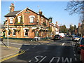
Watford: Nascot Arms public house
On Stamford Road at the corner of Nascot Place, the pub dates from 1869 and is contemporary with the Victorian housing development in the area. The pub is a Greene King house and the inn sign features Watford Council's coat of arms with the word 'audentior'. This comes from the Latin phrase 'Tu ne cede malis, sed contra audentior ito, quam tua te fortuna sinet', which roughly translates into 'Yield not to misfortunes, but advance all the more boldly against them'.
The distant church is Image Spot the cat!
Image: © Nigel Cox
Taken: 16 Feb 2008
0.16 miles
6
Stratford Way, Watford
Stratford Way is a residential road in Watford, Hertfordshire.
Image: © Malc McDonald
Taken: 23 Jun 2012
0.20 miles
8
Pedestrian crossing by West Herts College
Image: © David Howard
Taken: 24 Apr 2014
0.20 miles
9
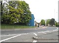
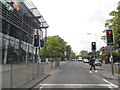
Junction at the end of Hempstead Road, Watford
This is a sort of figure of eight roundabout first crossing the A roads and then the local road here and college entrance behind this view.
Image: © David Howard
Taken: 24 Apr 2014
0.21 miles
10
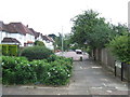
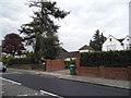
Woodland Drive, Watford
Woodland Drive is a residential road in Watford, Hertfordshire. It has been blocked off here to make it into a "no through road" for traffic, although pedestrians still have access.
Image: © Malc McDonald
Taken: 23 Jun 2012
0.21 miles