IMAGES TAKEN NEAR TO
Hempstead Road, WATFORD, WD17 3NL
Introduction
This page details the photographs taken nearby to Hempstead Road, WD17 3NL by members of the Geograph project.
The Geograph project started in 2005 with the aim of publishing, organising and preserving representative images for every square kilometre of Great Britain, Ireland and the Isle of Man.

There are currently over 7.5m images from over14,400 individuals and you can help contribute to the project by visiting https://www.geograph.org.uk
Image Map (Loading...)


Getting Data...Please wait
Leaflet Map data © OpenStreetMap
Images are licensed for reuse under creativecommons.org/licenses/by-sa/2.0
Notes
- Clicking on the map will re-center to the selected point.
- The higher the marker number, the further away the image location is from the centre of the postcode.
Image Listing (48 Images Found)
Images are licensed for reuse under creativecommons.org/licenses/by-sa/2.0
Image
Details
Distance
1
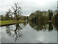
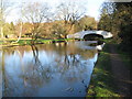
Grand Union Canal north of Bridge 163
Particularly wide, formerly there were wharves on the right.
Image: © Robin Webster
Taken: 10 Mar 2013
0.05 miles
3
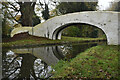
On Bridge 163, Grand Union Canal
A roving bridge where the towpath changes sides, only wide enough for a horse.
Image: © Robin Webster
Taken: 10 Mar 2013
0.06 miles
4
Grand Union Canal Walk
Grand Union Canal Walk at Lady Capel's Bridge No 163
Image: © Shaun Ferguson
Taken: 21 Mar 2017
0.06 miles
5
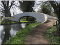
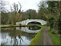
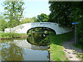
Grand Union Canal: Bridge Number 163
This structure is only a footbridge, at the edge of The Grove estate, that allows the towpath to cross from this, the east side, to the far, the west side of the canal. As with many bridges on the Grand Union Canal it has been painted white, which may be fine when the paintwork was new, but looks neglected as soon as the paint starts to peel off.
Immediately beyond the bridge the canal makes a sharp right-angled turn to the left.
The Ordnance Survey 1:50,000 scale mapping is woefully inaccurate here, presumably for cartographic presentation reasons, plotting the bridge some 70 metres away from its much more accurate position shown on the 1:10,000 scale.
Image: © Nigel Cox
Taken: 1 Jan 2010
0.07 miles
6
Bridge 163, Grand Union Canal
A roving bridge where the towpath changes sides, only wide enough for a horse.
Image: © Robin Webster
Taken: 10 Mar 2013
0.07 miles
7
Lady Capel?s Bridge
On the River Gade, part of the Grand Union Canal route.
Image: © David Martin
Taken: 14 Nov 2022
0.07 miles
8
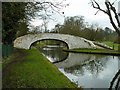
Roving bridge, Grand Union Canal
Bridge 163 enables a horse to cross where the towpath changes sides. It is very narrow, with just room enough for the horse.
Image: © Robin Webster
Taken: 10 Mar 2013
0.07 miles
10
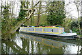
Hidden in the Gade
Just below Lady Capel's lock 74, the River Gade re-enters the canal. An adjacent landowner has taken advantage of the widening at this point to put a narrowboat in.
Image: © Graham Horn
Taken: 11 Apr 2010
0.08 miles