IMAGES TAKEN NEAR TO
Hempstead Road, WATFORD, WD17 3HH
Introduction
This page details the photographs taken nearby to Hempstead Road, WD17 3HH by members of the Geograph project.
The Geograph project started in 2005 with the aim of publishing, organising and preserving representative images for every square kilometre of Great Britain, Ireland and the Isle of Man.

There are currently over 7.5m images from over14,400 individuals and you can help contribute to the project by visiting https://www.geograph.org.uk
Image Map (Loading...)


Getting Data...Please wait
Leaflet Map data © OpenStreetMap
Images are licensed for reuse under creativecommons.org/licenses/by-sa/2.0
Notes
- Clicking on the map will re-center to the selected point.
- The higher the marker number, the further away the image location is from the centre of the postcode.
Image Listing (3 Images Found)
Images are licensed for reuse under creativecommons.org/licenses/by-sa/2.0
Image
Details
Distance
1
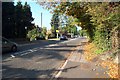
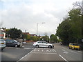
Watford: A411 Hempstead Road (The snapper snapped)
Viewed looking north-westwards towards the junction with Ridge Lane, this is a busy arterial road with five speed cameras between the Watford Town Hall roundabout and the Hunton Bridge roundabout. One of the speed cameras can be seen here.
Image: © Nigel Cox
Taken: 16 Oct 2005
0.02 miles
3
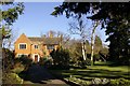
Cheslyn Gardens
3½ acres of tranquility off Nascot Wood Road. Woodland, borders, aviary, pond and shrubberies with a wide variety of wildlife. Free entry to the gardens all year (except 25th & 26th December).
Image: © David Marsden
Taken: 10 Feb 2008
0.18 miles