IMAGES TAKEN NEAR TO
Cassiobury Drive, WATFORD, WD17 3AE
Introduction
This page details the photographs taken nearby to Cassiobury Drive, WD17 3AE by members of the Geograph project.
The Geograph project started in 2005 with the aim of publishing, organising and preserving representative images for every square kilometre of Great Britain, Ireland and the Isle of Man.

There are currently over 7.5m images from over14,400 individuals and you can help contribute to the project by visiting https://www.geograph.org.uk
Image Map (Loading...)


Getting Data...Please wait
Leaflet Map data © OpenStreetMap
Images are licensed for reuse under creativecommons.org/licenses/by-sa/2.0
Notes
- Clicking on the map will re-center to the selected point.
- The higher the marker number, the further away the image location is from the centre of the postcode.
Image Listing (28 Images Found)
Images are licensed for reuse under creativecommons.org/licenses/by-sa/2.0
Image
Details
Distance
1
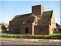
Watford: First Church of Christ, Scientist
The Church was built in an imposing location at the main entrance to the Cassiobury Estate from the town centre in the angle between Cassiobury Drive and Parkside Drive with a dual frontage onto each. This is the Parkside Drive side.
Christian Science was discovered (the Church's word, not mine) by Mary Baker Eddy (1821-1910), who founded The First Church of Christ, Scientist, in Boston, Massachusetts, USA, in 1879. Only the Mother Church in Boston is allowed to call itself The First Church; all other churches have to drop the definitive article. The Church's main website is here http://www.tfccs.com/index.jhtml
(From a Geograph point of view the church symbol is shown on the Ordnance Survey's 1:50,000 scale map in the grid square to the north Image However on the more accurate 1:10,000 scale mapping it is mapped entirely within this grid square.)
Image: © Nigel Cox
Taken: 21 Sep 2008
0.04 miles
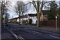
2

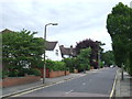
Watford: Cassiobury Drive
Cassiobury Drive used to be the main route leading into the Cassiobury Estate from the centre of Watford until the road was blocked off at Rickmansworth Road. This section is now a quiet dead-end.
(From a Geograph point of view this photograph was taken standing on the southern boundary of Image looking across the south-western corner to the western boundary.)
Image: © Nigel Cox
Taken: 21 Sep 2008
0.05 miles
3
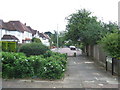
Woodland Drive, Watford
Woodland Drive is a residential road in Watford, Hertfordshire. It has been blocked off here to make it into a "no through road" for traffic, although pedestrians still have access.
Image: © Malc McDonald
Taken: 23 Jun 2012
0.07 miles
4
Stratford Way, Watford
Stratford Way is a residential road in Watford, Hertfordshire.
Image: © Malc McDonald
Taken: 23 Jun 2012
0.08 miles
5
Stratford Way, Watford
Stratford Way is a residential road in Watford, Hertfordshire. Trees line the street here.
Image: © Malc McDonald
Taken: 23 Jun 2012
0.08 miles
6
Stratford Way, Watford
Stratford Way is a residential road in Watford, Hertfordshire.
Image: © Malc McDonald
Taken: 23 Jun 2012
0.09 miles
7
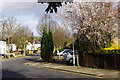
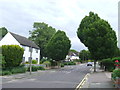
Stratford Way, Watford
Part of the Watford's leafy Cassiobury Estate. Note the tree in blossom - and this is still January!
Image: © Stephen McKay
Taken: 30 Jan 2016
0.09 miles
9
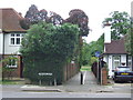
Path to Cassiobury Park, Watford
This path, which is shared by pedestrians and cyclists, leads into Cassiobury Park in Watford.
Image: © Malc McDonald
Taken: 23 Jun 2012
0.11 miles
10
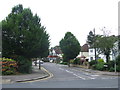
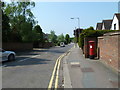
Cassiobury Drive, Watford
Seen from the junction with Stratford Way, Cassiobury Drive is part of a residential estate on land that was once part of the Earls of Essex's country estate. The land was sold with a covenant that only good quality detached and semi-detached houses could be built and the area remains a desirable one to this day.
Image: © Stephen McKay
Taken: 30 Jan 2016
0.12 miles