IMAGES TAKEN NEAR TO
Ebury Road, WATFORD, WD17 2SB
Introduction
This page details the photographs taken nearby to Ebury Road, WD17 2SB by members of the Geograph project.
The Geograph project started in 2005 with the aim of publishing, organising and preserving representative images for every square kilometre of Great Britain, Ireland and the Isle of Man.

There are currently over 7.5m images from over14,400 individuals and you can help contribute to the project by visiting https://www.geograph.org.uk
Image Map (Loading...)


Getting Data...Please wait
Leaflet Map data © OpenStreetMap
Images are licensed for reuse under creativecommons.org/licenses/by-sa/2.0
Notes
- Clicking on the map will re-center to the selected point.
- The higher the marker number, the further away the image location is from the centre of the postcode.
Image Listing (67 Images Found)
Images are licensed for reuse under creativecommons.org/licenses/by-sa/2.0
Image
Details
Distance
1
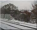
Railway infrastructure by the West Coast Main Line, Watford
Image: © N Chadwick
Taken: 19 Dec 2010
0.04 miles
2
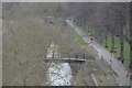
Recreation ground by the River Colne
Image: © Mike Quinn
Taken: 15 Jan 2020
0.06 miles
3
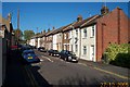
Watford: Ebury Road
A fine terrace of Victorian houses, with front doors opening on to the street.
Image: © Nigel Cox
Taken: 27 Oct 2005
0.08 miles
4
Coal tax boundary obelisk no.45 by the River Colne - plaque
See Image
Image: © Mike Quinn
Taken: 15 Jan 2020
0.09 miles
5
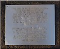
Coal tax boundary obelisk no.45 by the River Colne - remains of lettering
See Image I do not know what the original inscription was. Two other obelisks that I have seen had only "14 & 15 VICT / CAP 146" - see Image and Image
Image: © Mike Quinn
Taken: 15 Jan 2020
0.09 miles
6

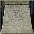
Coal tax boundary obelisk no.45 by the River Colne - City of London coat of arms
See Image
Image: © Mike Quinn
Taken: 15 Jan 2020
0.09 miles
7
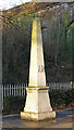
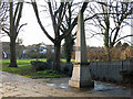
Coal tax boundary obelisk no.45 by the River Colne
The location of this obelisk is shown in Image, Image, Image and Image The base of the obelisk can also be seen in Image (photographed by Nigel Cox).
The obelisk was originally on the opposite (south) bank of the river; it was re-erected by Watford Borough Council in 1984, after it had been lying there in pieces since 1961 - see Image
The obelisk is Grade II https://historicengland.org.uk/listing/the-list/list-entry/1101112.
There were originally nearly 280 coal tax posts located around London, of which about 210 are still extant; around 180 of these (85%) are 3 ft high white-painted square bollards with a pyramidal top, decorative raised bands, and the shield from the City of London’s arms - such as the nearby Image
There are just 13 stone obelisks of the type in the photo, all erected by railways that were opened before 1865. The posts were erected under the Coal and Wine Duties (Continuation) Act of 1861 to mark the points at which duty had to be paid on coal being transported to London. The boundary was set at that of the Metropolitan Police District, and the resulting revenue was used by the Corporation of the City of London to fund public works. For further info see http://www.coaldutyposts.org.uk/cityposts.html .
Photos of the coal tax posts on Geograph are at http://www.geograph.org.uk/search.php?i=86542993&page=1 .
Image: © Mike Quinn
Taken: 15 Jan 2020
0.09 miles
8
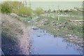
River Colne Waterfields Recreation Ground
View upstream from a position near the railway bridge, before landscaping of the river corridor was completed.
Image: © David Leeming
Taken: 10 Apr 1997
0.10 miles
9
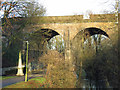
Railway viaduct over the River Colne
Image: © Mike Quinn
Taken: 15 Jan 2020
0.10 miles