IMAGES TAKEN NEAR TO
Colne Valley Retail Park, Lower High Street, WATFORD, WD17 2JZ
Introduction
This page details the photographs taken nearby to Colne Valley Retail Park, Lower High Street, WD17 2JZ by members of the Geograph project.
The Geograph project started in 2005 with the aim of publishing, organising and preserving representative images for every square kilometre of Great Britain, Ireland and the Isle of Man.

There are currently over 7.5m images from over14,400 individuals and you can help contribute to the project by visiting https://www.geograph.org.uk
Image Map (Loading...)


Getting Data...Please wait
Leaflet Map data © OpenStreetMap
Images are licensed for reuse under creativecommons.org/licenses/by-sa/2.0
Notes
- Clicking on the map will re-center to the selected point.
- The higher the marker number, the further away the image location is from the centre of the postcode.
Image Listing (36 Images Found)
Images are licensed for reuse under creativecommons.org/licenses/by-sa/2.0
Image
Details
Distance
5
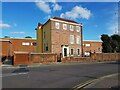
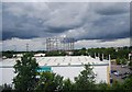
Watford: Frogmore House
Frogmore House is a Grade II* Listed Building in the Lower High Street.
It was built in 1716, and has survived all the redevelopment of the area around it. Around 1905 it was bought by the local gas company, and up to quite recently the now demolished gasometer immediately behind it would have dominated this viewpoint. The house had fallen into a state of disrepair but was very recently refurbished, at a cost of about £2 million, by the developer of the new Lidl supermarket now visible behind it.
This is the four window street elevation with blank openings. The main five window frontage is around to the right.
Image: © Nigel Cox
Taken: 7 Oct 2020
0.11 miles
6
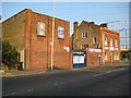
Watford: Geo. Ausden metal recyclers
The Ausden family have been serving Watford's metal recycling needs since 1901. These are their premises in the Lower High Street that they have occupied since 1925. Their website is here http://www.imarco-online.com/clients/ausden/index2.htm
The building on the right is Brookland, a locally listed house dating from 1911.
Image: © Nigel Cox
Taken: 30 Aug 2008
0.11 miles
7
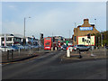
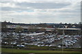
Lower High Street, Watford
A workaday part of Watford that seems to be mainly given over to the needs of the motor car. A bus is heading towards the town centre, to the right the A411 Waterfields Way by-passes the High Street. On the left is a large car dealership.
Image: © Stephen McKay
Taken: 16 Jan 2016
0.12 miles
8
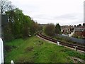
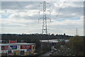
Croxley Green Branch from mainline
This is a picture of the location where the now disused Croxley Green branch (closed in 1996) diverges from the mainline. The branch may be re-used in the future as part of a Metropolitan Line extension to Watford Junction.
Image: © Hywel Williams
Taken: 16 Apr 2005
0.12 miles
9
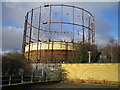
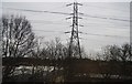
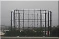
Watford: Gasometer
Viewed from the Colne Valley Retail Park. The River Colne runs in the concrete conduit beyond the near railings to the left.
Image: © Nigel Cox
Taken: 27 Dec 2005
0.12 miles