IMAGES TAKEN NEAR TO
Lower High Street, WATFORD, WD17 2JX
Introduction
This page details the photographs taken nearby to Lower High Street, WD17 2JX by members of the Geograph project.
The Geograph project started in 2005 with the aim of publishing, organising and preserving representative images for every square kilometre of Great Britain, Ireland and the Isle of Man.

There are currently over 7.5m images from over14,400 individuals and you can help contribute to the project by visiting https://www.geograph.org.uk
Image Map (Loading...)


Getting Data...Please wait
Leaflet Map data © OpenStreetMap
Images are licensed for reuse under creativecommons.org/licenses/by-sa/2.0
Notes
- Clicking on the map will re-center to the selected point.
- The higher the marker number, the further away the image location is from the centre of the postcode.
Image Listing (56 Images Found)
Images are licensed for reuse under creativecommons.org/licenses/by-sa/2.0
Image
Details
Distance
1
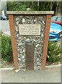
Old Boundary Marker on the A411 Lower High Street, Watford
Turnpike Terminus Marker on the northeast side of the A411 Lower High Street in Watford. In raised lettering SPARROWS / HERNE / TRUST. See https://en.wikipedia.org/wiki/Sparrows_Herne_Turnpike_Road. Grade II Listed details https://historicengland.org.uk/listing/the-list/list-entry/1250997. See also https://www.geograph.org.uk/photo/4803063.
Milestone Society National ID: HE_WFSHt
Image: © D Tylden-Pattenson
Taken: 21 Apr 2022
0.05 miles
2

Sparrows Herne Trust marker, by Bushey Arches
The Sparrows Herne Turnpike Trust was established in 1762 to maintain 26 miles of the London - Aylesbury road. This marker has survived on what is now the A411 between Bushey and Watford.
Image: © Stephen McKay
Taken: 16 Jan 2016
0.05 miles
4
West Coast Main Line between Watford Junction and Bushey Stations
Image: © N Chadwick
Taken: 19 Dec 2010
0.06 miles
5
West Coast Main Line viaduct over Colne valley
Inscribed 'HAPPY 30TH BIRTHDAY SIZ LOVE 4EVA PAN XXX' - unusual names.
Image: © Robin Webster
Taken: 10 Mar 2013
0.07 miles
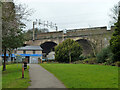
6

Bushey Arches
A 142 bus from Watford Junction to Brent Cross heads under the viaduct that carries the West Coast Main Line just north of Bushey Station.
Image: © Stephen McKay
Taken: 16 Jan 2016
0.08 miles
7
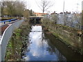
Watford: River Colne
Viewed looking westwards and downstream towards the Lower High Street bridge.
Image: © Nigel Cox
Taken: 27 Dec 2005
0.09 miles
8
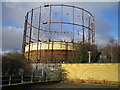
Watford: Gasometer
Viewed from the Colne Valley Retail Park. The River Colne runs in the concrete conduit beyond the near railings to the left.
Image: © Nigel Cox
Taken: 27 Dec 2005
0.11 miles
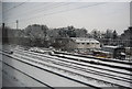
9
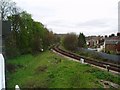
Croxley Green Branch from mainline
This is a picture of the location where the now disused Croxley Green branch (closed in 1996) diverges from the mainline. The branch may be re-used in the future as part of a Metropolitan Line extension to Watford Junction.
Image: © Hywel Williams
Taken: 16 Apr 2005
0.11 miles
10
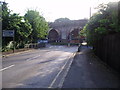
Railway Viaduct
This side shows the original structure. The other side shows how it has been widened.
Image: © Bikeboy
Taken: 23 Jun 2012
0.11 miles