IMAGES TAKEN NEAR TO
Bedford Street, LONDON, WC2E 9ES
Introduction
This page details the photographs taken nearby to Bedford Street, WC2E 9ES by members of the Geograph project.
The Geograph project started in 2005 with the aim of publishing, organising and preserving representative images for every square kilometre of Great Britain, Ireland and the Isle of Man.

There are currently over 7.5m images from over14,400 individuals and you can help contribute to the project by visiting https://www.geograph.org.uk
Image Map
Images are licensed for reuse under creativecommons.org/licenses/by-sa/2.0
Notes
- Clicking on the map will re-center to the selected point.
- The higher the marker number, the further away the image location is from the centre of the postcode.
Image Listing (4105 Images Found)
Images are licensed for reuse under creativecommons.org/licenses/by-sa/2.0
Image
Details
Distance
2
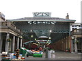
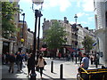
Covent Garden
Covent Garden was the name given, during the reign of King John (1199 - 1256), to a 40 acre patch in the county of Middlesex, bordered west and east by which is now St. Martin’s Lane and Drury Lane, and north and south By Floral Street and a line drawn from Chandos Place, along Maiden Lane and Exeter Street to the Aldwych. Charles Fowler’s designed covered market in the middle of Piazza was completed in 1830. It looked much as it does today except that the two main aisles were uncovered. The glass roofs were added separately in 1875 and 1889. In 1964 the Covent Garden Market Authority (CGMA) decided to move the market to Nine Elms in Battersea.
Left empty in 1974 the Central Market Building was preserved and renovated by the Greater London Council, and reopened in 1980 as a complex of shops, boutiques, and open-air restaurants. ( http://www.covent-garden.co.uk/index.html )
Image: © Richard Rogerson
Taken: 26 Mar 2009
0.01 miles
3
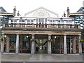
Punch and Judy, Covent Garden
The Punch and Judy is in the middle of the Covent Garden Piazza. It is spread over two floors. The lower level is in the marketplace itself.
Image: © Richard Rogerson
Taken: 26 Mar 2009
0.01 miles
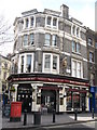
4
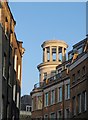
Tower, Garrick Street, London
The open circular tower is above Tesco on the corner of Bedford Street, King Street and New Row. http://www.british-history.ac.uk/report.aspx?compid=46128#s9 suggests that this is a replacement for a "Gothic conecapped tower" of 1875-6 which adorned the demolished Moss Bros.
Image: © Derek Harper
Taken: 6 Feb 2010
0.01 miles
5
New Row, WC2
Featuring pubs the White Swan and the Roundhouse, whose inn signs are showing right and left.
Image: © Robin Webster
Taken: 21 Nov 2015
0.01 miles
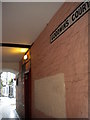
6
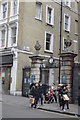
Gateway to Inigo Place
Grade II listed. http://www.britishlistedbuildings.co.uk/en-208624-gateway-to-inigo-place-and-st-pauls-chur
Image: © N Chadwick
Taken: 24 Apr 2016
0.01 miles
7
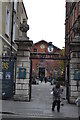
Gateway to Inigo Place
Grade II listed. http://www.britishlistedbuildings.co.uk/en-208624-gateway-to-inigo-place-and-st-pauls-chur
Image: © N Chadwick
Taken: 24 Apr 2016
0.01 miles
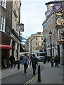
8
View of the King Street/Bedford Street/New Row/Garrick Street junction from King Street
Looking north-northwest.
Image: © Robert Lamb
Taken: 8 Jun 2013
0.02 miles
9
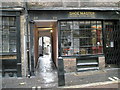
Delightful alleyway running off Bedfordbury
Image: © Basher Eyre
Taken: 26 Oct 2008
0.02 miles