IMAGES TAKEN NEAR TO
Dorothy Street, ST. HELENS, WA9 5RP
Introduction
This page details the photographs taken nearby to Dorothy Street, WA9 5RP by members of the Geograph project.
The Geograph project started in 2005 with the aim of publishing, organising and preserving representative images for every square kilometre of Great Britain, Ireland and the Isle of Man.

There are currently over 7.5m images from over14,400 individuals and you can help contribute to the project by visiting https://www.geograph.org.uk
Image Map
Images are licensed for reuse under creativecommons.org/licenses/by-sa/2.0
Notes
- Clicking on the map will re-center to the selected point.
- The higher the marker number, the further away the image location is from the centre of the postcode.
Image Listing (8 Images Found)
Images are licensed for reuse under creativecommons.org/licenses/by-sa/2.0
Image
Details
Distance
3
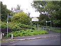
Elm Road crosses the St Helen's Liverpool railway
Notice boards and fingerpost indicate the Ravenhead Greenway in the background
Image: © Raymond Knapman
Taken: 11 Aug 2010
0.18 miles
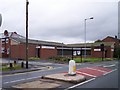
6
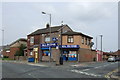
Rainbow Medical Centre on Elephant Lane
Image: © Raymond Knapman
Taken: 11 Aug 2010
0.22 miles
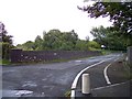
7
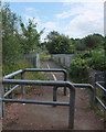
Bridge between Ravenhead Colliery and Thatto Heath
Image: © Gary Rogers
Taken: 23 Aug 2017
0.22 miles
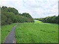
8
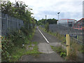
Path from Ravenhead Road to Alexandra Colliery
Image: © Gary Rogers
Taken: 23 Aug 2017
0.24 miles