IMAGES TAKEN NEAR TO
St. Helens Linkway, ST. HELENS, WA9 5DT
Introduction
This page details the photographs taken nearby to St. Helens Linkway, WA9 5DT by members of the Geograph project.
The Geograph project started in 2005 with the aim of publishing, organising and preserving representative images for every square kilometre of Great Britain, Ireland and the Isle of Man.

There are currently over 7.5m images from over14,400 individuals and you can help contribute to the project by visiting https://www.geograph.org.uk
Image Map
Images are licensed for reuse under creativecommons.org/licenses/by-sa/2.0
Notes
- Clicking on the map will re-center to the selected point.
- The higher the marker number, the further away the image location is from the centre of the postcode.
Image Listing (17 Images Found)
Images are licensed for reuse under creativecommons.org/licenses/by-sa/2.0
Image
Details
Distance
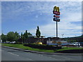
5
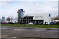
Pentagon Ford Dealership
Car showroom, Sherdley Road, St Helens.
Image: © David Dixon
Taken: 24 Mar 2019
0.08 miles
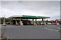
6
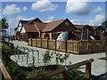
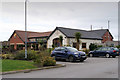
The Glass Horse pub
Hungry Horse pub on Sherdley Road.
Image: © JThomas
Taken: 5 Jun 2014
0.08 miles
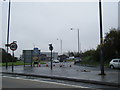
8
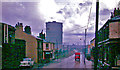
Industrial Lancashire in 1963: near Peasley Cross
View southwards on A570.
Image: © Ben Brooksbank
Taken: 20 Aug 1963
0.12 miles
9
The Glass Horse
Pub/restaurant on Sherdley Road, St Helens
Image: © David Dixon
Taken: 24 Mar 2019
0.12 miles
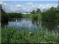
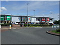
10
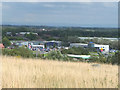
Ravenhead Retail Park from Ravenhead Nature Park
Image: © Gary Rogers
Taken: 23 Aug 2017
0.14 miles