IMAGES TAKEN NEAR TO
Wisteria Way, ST. HELENS, WA9 4LN
Introduction
This page details the photographs taken nearby to Wisteria Way, WA9 4LN by members of the Geograph project.
The Geograph project started in 2005 with the aim of publishing, organising and preserving representative images for every square kilometre of Great Britain, Ireland and the Isle of Man.

There are currently over 7.5m images from over14,400 individuals and you can help contribute to the project by visiting https://www.geograph.org.uk
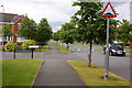
Image Map
Images are licensed for reuse under creativecommons.org/licenses/by-sa/2.0
Notes
- Clicking on the map will re-center to the selected point.
- The higher the marker number, the further away the image location is from the centre of the postcode.
Image Listing (6 Images Found)
Images are licensed for reuse under creativecommons.org/licenses/by-sa/2.0
Image
Details
Distance
1
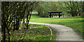
Bench at New Bold Green
Bench at the end of the lake at New Bold Green, former site of Bold Colliery
Image: © Cara Donovan
Taken: 16 Apr 2010
0.08 miles
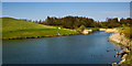
2
Bridge over lake at New Bold Green
View of bridge across lake at New Bold Green
Image: © Cara Donovan
Taken: 12 Oct 2009
0.11 miles
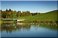
3
New Bold Green Lake
Man made lake on the site of the old Bold Colliery. Part of the landscape of the nearby housing development.
Image: © Cara Donovan
Taken: 17 Apr 2010
0.15 miles
4
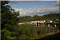
Travellers' site, as seen from the 12.01 from Newton-le-Willows
Image: © David Long
Taken: 8 Oct 2009
0.16 miles
6
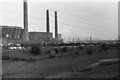
Bold Power Station
May 1980 was the 150th anniversary of the original Rainhill Trials which was won by the "Rocket". In May 1980 British Rail re-enacted these trials on the same stretch of the Liverpool to Manchester Railway.
Bold power station was used to service the locos.
Image: © David Ashcroft
Taken: Unknown
0.24 miles