IMAGES TAKEN NEAR TO
Eton Hall Drive, ST. HELENS, WA9 3XD
Introduction
This page details the photographs taken nearby to Eton Hall Drive, WA9 3XD by members of the Geograph project.
The Geograph project started in 2005 with the aim of publishing, organising and preserving representative images for every square kilometre of Great Britain, Ireland and the Isle of Man.

There are currently over 7.5m images from over14,400 individuals and you can help contribute to the project by visiting https://www.geograph.org.uk
Image Map
Images are licensed for reuse under creativecommons.org/licenses/by-sa/2.0
Notes
- Clicking on the map will re-center to the selected point.
- The higher the marker number, the further away the image location is from the centre of the postcode.
Image Listing (4 Images Found)
Images are licensed for reuse under creativecommons.org/licenses/by-sa/2.0
Image
Details
Distance
2
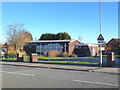
Methodist Church, New Street, Sutton
Banner reads "150 years of Methodism in Sutton"
Image: © Gary Rogers
Taken: 23 Feb 2016
0.22 miles
3
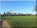
Sign at entrance to Sutton Park from Marina Avenue
Image: © Gary Rogers
Taken: 23 Feb 2016
0.24 miles
4
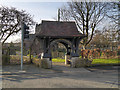
Parish Church of St Nicholas, Sutton
The parish church of St Nicholas at Sutton was built between 1847 and 1849. It is a Grade II listed building (http://list.english-heritage.org.uk/resultsingle.aspx?uid=1199239 National heritage List for England).
Image: © David Dixon
Taken: 8 Feb 2013
0.25 miles