IMAGES TAKEN NEAR TO
Massey Street, ST. HELENS, WA9 3NL
Introduction
This page details the photographs taken nearby to Massey Street, WA9 3NL by members of the Geograph project.
The Geograph project started in 2005 with the aim of publishing, organising and preserving representative images for every square kilometre of Great Britain, Ireland and the Isle of Man.

There are currently over 7.5m images from over14,400 individuals and you can help contribute to the project by visiting https://www.geograph.org.uk
Image Map
Images are licensed for reuse under creativecommons.org/licenses/by-sa/2.0
Notes
- Clicking on the map will re-center to the selected point.
- The higher the marker number, the further away the image location is from the centre of the postcode.
Image Listing (14 Images Found)
Images are licensed for reuse under creativecommons.org/licenses/by-sa/2.0
Image
Details
Distance
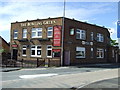
3
Junction with Robins Lane and Baxters Lane, St.Helens
This is the junction with Robins Lane and Baxters Lane, Sutton, St.Helens. The Bowling Green pub has joined us on this particular picture... fancy a beer?
Image: © andy
Taken: 17 Jul 2005
0.14 miles
5
Sutton Park
Paths at the entrance from Robins Lane/Marina Avenue
Image: © Kevin Waterhouse
Taken: 3 Jan 2025
0.16 miles
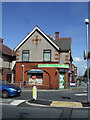
6
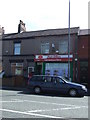
Post Office and convenience store on Robins Lane
Image: © JThomas
Taken: 5 Jun 2014
0.17 miles
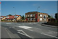
8
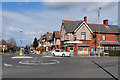
Marshall's Cross Road
The junction of Marshall's Cross Road with Robins Lane.
Image: © David Dixon
Taken: 24 Mar 2019
0.22 miles
9
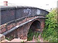
Baxters Lane crosses the disused railway at Peasley Cross
View showing detail of brickwork of the locally known Dutch Barn Bridge
Image: © Raymond Knapman
Taken: 7 Aug 2010
0.22 miles
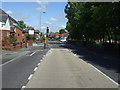
10
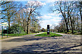
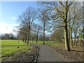
Sutton Park, St Helens
Sutton Park is situated between Robins Lane, Marshalls Cross Road and Marina Avenue and is the oldest public park in Sutton.
Image: © David Dixon
Taken: 24 Mar 2019
0.22 miles