IMAGES TAKEN NEAR TO
Sutton Fold, ST. HELENS, WA9 3GL
Introduction
This page details the photographs taken nearby to Sutton Fold, WA9 3GL by members of the Geograph project.
The Geograph project started in 2005 with the aim of publishing, organising and preserving representative images for every square kilometre of Great Britain, Ireland and the Isle of Man.

There are currently over 7.5m images from over14,400 individuals and you can help contribute to the project by visiting https://www.geograph.org.uk
Image Map
Images are licensed for reuse under creativecommons.org/licenses/by-sa/2.0
Notes
- Clicking on the map will re-center to the selected point.
- The higher the marker number, the further away the image location is from the centre of the postcode.
Image Listing (18 Images Found)
Images are licensed for reuse under creativecommons.org/licenses/by-sa/2.0
Image
Details
Distance
1
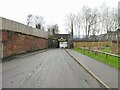
Disused railway bridge over Lancots Lane
The dismantled railway connected central St Helens with St Helens Junction on the Liverpool to Manchester line.
Image: © Kevin Waterhouse
Taken: 3 Jan 2025
0.11 miles
2
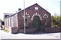
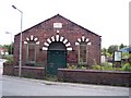
Sutton Oak Welsh Chapel, St Helens
The Sutton Oak Welsh Chapel was built by the Wesleyan Methodists in 1845. It was constructed using cobbles made from copper slag from the copper works on the Sutton banks of the St.Helens canal. The nonconfirmist Welsh congregation acquired it in 1893, having previously occupied a room provided by a local firm - as the only way in was through a hole in the wall, this was known as “The Hole in the Wall Chapel”.
Image: © S Parish
Taken: 3 May 2006
0.13 miles
5
Gable end of the Welsh Chapel on Sutton Road
Image: © Raymond Knapman
Taken: 7 Aug 2010
0.16 miles
6
The Welsh chapel on Sutton Road
Constructed with copper slag cobbles giving it a blackened appearance.
Image: © Raymond Knapman
Taken: 7 Aug 2010
0.16 miles
7
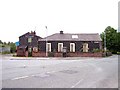
The Glassmakers Arms, Waterdale Crescent, Sutton
Closed down.
Image: © Gary Rogers
Taken: 23 Feb 2016
0.17 miles
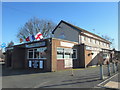
8
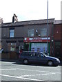
Post Office and convenience store on Robins Lane
Image: © JThomas
Taken: 5 Jun 2014
0.18 miles
9
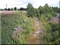
End of the line?
View from Dutch Barn Bridge showing the remains of the disused St Helens to St Helens Junction branch.
Image: © Raymond Knapman
Taken: 7 Aug 2010
0.19 miles
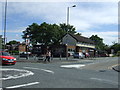
10
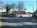
Junction of Waterdale Crescent and Gerrards Lane, Sutton
Image: © Gary Rogers
Taken: 23 Feb 2016
0.20 miles