IMAGES TAKEN NEAR TO
Brook Cottage Close, ST. HELENS, WA9 3BB
Introduction
This page details the photographs taken nearby to Brook Cottage Close, WA9 3BB by members of the Geograph project.
The Geograph project started in 2005 with the aim of publishing, organising and preserving representative images for every square kilometre of Great Britain, Ireland and the Isle of Man.

There are currently over 7.5m images from over14,400 individuals and you can help contribute to the project by visiting https://www.geograph.org.uk
Image Map
Images are licensed for reuse under creativecommons.org/licenses/by-sa/2.0
Notes
- Clicking on the map will re-center to the selected point.
- The higher the marker number, the further away the image location is from the centre of the postcode.
Image Listing (7 Images Found)
Images are licensed for reuse under creativecommons.org/licenses/by-sa/2.0
Image
Details
Distance
1
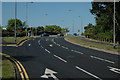
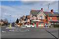
Junction at Peasley Cross
This is the junction of Sutton Road, Jackson Street and Gaskell Street in Peasley Cross near St.Helens.
Image: © andy
Taken: 17 Jul 2005
0.17 miles

3
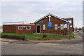
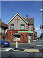
Peasley Cross URC
United Reformed Church at Peasley Cross.
Image: © David Dixon
Taken: 24 Mar 2019
0.21 miles
4
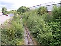
Nature takes over the St Helens Junction branch
Viewed from Sutton Road bridge the redundant railway is being submersed in vegetation
Image: © Raymond Knapman
Taken: 7 Aug 2010
0.22 miles
5
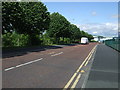
Sullivan's Way
Industrial estate road off the A569
Image: © JThomas
Taken: 5 Jun 2014
0.24 miles
7
Marshall's Cross Road
The junction of Marshall's Cross Road with Robins Lane.
Image: © David Dixon
Taken: 24 Mar 2019
0.25 miles