IMAGES TAKEN NEAR TO
Ketterer Court, ST. HELENS, WA9 3AH
Introduction
This page details the photographs taken nearby to Ketterer Court, WA9 3AH by members of the Geograph project.
The Geograph project started in 2005 with the aim of publishing, organising and preserving representative images for every square kilometre of Great Britain, Ireland and the Isle of Man.

There are currently over 7.5m images from over14,400 individuals and you can help contribute to the project by visiting https://www.geograph.org.uk
Image Map
Images are licensed for reuse under creativecommons.org/licenses/by-sa/2.0
Notes
- Clicking on the map will re-center to the selected point.
- The higher the marker number, the further away the image location is from the centre of the postcode.
Image Listing (12 Images Found)
Images are licensed for reuse under creativecommons.org/licenses/by-sa/2.0
Image
Details
Distance
1
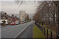
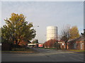
Jackson Street and its conspicuous gasometer
Image: © Ian Greig
Taken: 13 Jan 2011
0.07 miles
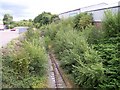
2
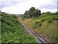
The St Helens Junction branch at Sutton Road bridge
Viewed towards the town centre, the rails look in good condition, but it has been many years since they saw a train.
Image: © Raymond Knapman
Taken: 7 Aug 2010
0.11 miles
3
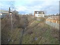
Site of former Peasley Cross railway station
The station was on a route linking central St Helens with St Helens Junction on the Liverpool to Manchester line. The line with the junction was subsequently severed and the remainder became a freight only line to a local works, but now looks to be abandoned. This view is from the bridge on Sutton Road.
Image: © Kevin Waterhouse
Taken: 3 Jan 2025
0.15 miles
4
Peasley Cross URC
United Reformed Church at Peasley Cross.
Image: © David Dixon
Taken: 24 Mar 2019
0.18 miles
5
Peasley Cross Road
Peasley Cross Road and the landmark gasometer, visible for miles aeound.
Image: © Sue Adair
Taken: 4 Nov 2007
0.18 miles
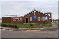
6
Entrance to Saints Retail Park
Junction of Peasley Cross Lane and McManus Drive.
Image: © Richard Cooke
Taken: 13 Feb 2021
0.19 miles
7
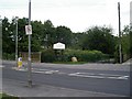
Sutton Brook Greenway
St Helens is criss-crossed with these "greenways", other examples being the Sankey Valley Park, the Ravenhead Greenway and the Newton Greenway. In addition to providing natural habitat corridors within the urban area, they provide good walking and cycling short cuts.
The image shows Gaskell Street crossing the Sutton Brook Greenway with the brook itself flowing under the road bridge to join the Sankey Brook and eventually the River Mersey.
Sutton Brook was also known locally as "Stinky Brook", a result of historical pollution from the local chemical industry.
Image: © Roy Prescott
Taken: 5 Sep 2006
0.20 miles

9
Nature takes over the St Helens Junction branch
Viewed from Sutton Road bridge the redundant railway is being submersed in vegetation
Image: © Raymond Knapman
Taken: 7 Aug 2010
0.22 miles
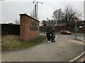
10
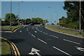
Junction at Peasley Cross
This is the junction of Sutton Road, Jackson Street and Gaskell Street in Peasley Cross near St.Helens.
Image: © andy
Taken: 17 Jul 2005
0.22 miles