IMAGES TAKEN NEAR TO
Phoenix Brow, ST. HELENS, WA9 1SA
Introduction
This page details the photographs taken nearby to Phoenix Brow, WA9 1SA by members of the Geograph project.
The Geograph project started in 2005 with the aim of publishing, organising and preserving representative images for every square kilometre of Great Britain, Ireland and the Isle of Man.

There are currently over 7.5m images from over14,400 individuals and you can help contribute to the project by visiting https://www.geograph.org.uk
Image Map
Images are licensed for reuse under creativecommons.org/licenses/by-sa/2.0
Notes
- Clicking on the map will re-center to the selected point.
- The higher the marker number, the further away the image location is from the centre of the postcode.
Image Listing (67 Images Found)
Images are licensed for reuse under creativecommons.org/licenses/by-sa/2.0
Image
Details
Distance
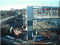
1
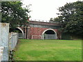
Corporation Road crosses site of Sankey Canal
View from footpath alongside the canal alignment.
Image: © Raymond Knapman
Taken: 3 Aug 2009
0.02 miles
2
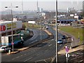
Parr Street, St. Helens
Parr Street is the main road into the town from the east. This view, at the junction with Corporation Street, shows some of the remaining industrial infrastructure to the town behind the roundabouts and the flatpack sheds.
Image: © Chris Denny
Taken: 2 Mar 2010
0.04 miles
3
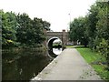
Corporation Road crosses site of Sankey Canal
View from the North side which is in water
Image: © Raymond Knapman
Taken: 3 Aug 2009
0.05 miles
5
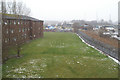
Ripe for restoration
As part of its Eastside Development of its Town Centre, St. Helens MBC hopes that this infilled section of the Sankey Canal will be restored as a centrepiece of the redevelopment.
Image: © David Long
Taken: 8 Feb 2007
0.06 miles
6
Well under way
The new office block for Helena Housing rises at the eastern end of Corporation Street. Compare with Image] taken from the same spot three months earlier.
Image: © Chris Denny
Taken: 28 Jan 2011
0.06 miles
7
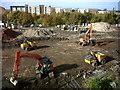
Preparing the ground
Ground clearance in progress in preparation for the building of a new office block for Helena Housing.
Image: © Chris Denny
Taken: 27 Oct 2010
0.07 miles
8
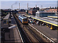
St Helens station - 1992
A station which looks to have been "rationalised".
Image: © The Carlisle Kid
Taken: 29 Aug 1992
0.08 miles
9
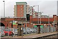
Signal, St. Helens Central railway station
Signal SH3 at the northern end of the Wigan-bound platform. Behind the signal is the station car park and Corporation Street.
Image: © El Pollock
Taken: 30 Dec 2013
0.08 miles
10
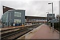
Bridges, St. Helens Central railway station
The station footbridge is in the foreground. To the background is the Corporation Street road bridge.
Image: © El Pollock
Taken: 30 Dec 2013
0.09 miles