IMAGES TAKEN NEAR TO
Pocket Nook Street, ST. HELENS, WA9 1LR
Introduction
This page details the photographs taken nearby to Pocket Nook Street, WA9 1LR by members of the Geograph project.
The Geograph project started in 2005 with the aim of publishing, organising and preserving representative images for every square kilometre of Great Britain, Ireland and the Isle of Man.

There are currently over 7.5m images from over14,400 individuals and you can help contribute to the project by visiting https://www.geograph.org.uk
Image Map
Images are licensed for reuse under creativecommons.org/licenses/by-sa/2.0
Notes
- Clicking on the map will re-center to the selected point.
- The higher the marker number, the further away the image location is from the centre of the postcode.
Image Listing (30 Images Found)
Images are licensed for reuse under creativecommons.org/licenses/by-sa/2.0
Image
Details
Distance
2
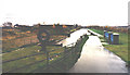
Site of railway swing bridge at Pocket Nook
The bridge swivelled on the Eastern bank of the Sankey Canal
Image: © Raymond Knapman
Taken: 3 Aug 2009
0.07 miles
3
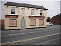
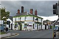
Last orders called
The Furnacemans Arms, Pocket Nook Street, one of many closed pubs in the area.
Image: © Chris Denny
Taken: 23 Apr 2010
0.07 miles
4
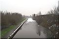
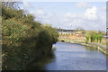
Restored Sankey Canal from Corporation Street
The view from the opposite end from that shown in the First Geograph.
Image: © David Long
Taken: 8 Feb 2007
0.15 miles
5
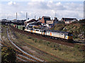
Trains at St Helens - 1992 (4)
The diverted 07.00 Crewe - Glasgow container train heads away from St Helens station.
Image: © The Carlisle Kid
Taken: 29 Aug 1992
0.15 miles
6
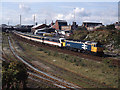
Trains at St Helens - 1992 (3)
The diverted 07.15 passenger service from Euston to Preston heads away from St Helens station.
Image: © The Carlisle Kid
Taken: 29 Aug 1992
0.15 miles
8
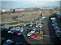
Endless parking, St. Helens
This private car park and access road to a recent local authority office development is on the site of former industrial land (the Atlas Foundry once occupied this site) adjacent to the St Helens Canal behind the trees.
Image: © Chris Denny
Taken: 2 Mar 2010
0.17 miles
9
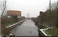
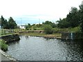
Restored section of the Sankey Canal
Various sections of the Sankey Canal have been restored over the past twenty years. This is one of the earlier restorations. It was carried out when the St. Helens' Technology Campus (right) was built, and provides a pleasant ambience for the staff there... though not all might enjoy the nostalgia of seeing one of the last, genuine gas-works walls in the region.
Image: © David Long
Taken: 8 Feb 2007
0.17 miles