IMAGES TAKEN NEAR TO
Cornerhouse Lane, WIDNES, WA8 9WD
Introduction
This page details the photographs taken nearby to Cornerhouse Lane, WA8 9WD by members of the Geograph project.
The Geograph project started in 2005 with the aim of publishing, organising and preserving representative images for every square kilometre of Great Britain, Ireland and the Isle of Man.

There are currently over 7.5m images from over14,400 individuals and you can help contribute to the project by visiting https://www.geograph.org.uk
Image Map
Images are licensed for reuse under creativecommons.org/licenses/by-sa/2.0
Notes
- Clicking on the map will re-center to the selected point.
- The higher the marker number, the further away the image location is from the centre of the postcode.
Image Listing (6 Images Found)
Images are licensed for reuse under creativecommons.org/licenses/by-sa/2.0
Image
Details
Distance
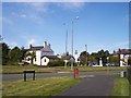
1
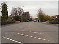
Prescot Road
Looking north along Prescot Road.
Image: © David Dixon
Taken: 23 Apr 2013
0.15 miles
2
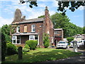
Upton House, Old Upton Lane
Upton House is a 19th century house on Old Upton Lane admid the modern housing estate of Upton Rocks.
Image: © Sue Adair
Taken: 14 Jun 2020
0.16 miles
3
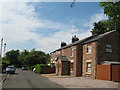
Old Upton Lane
Old Upton Lane with Blair Cottages on the right, not so long ago a winding country lane to Upton Rocks, now not much more than a footpath through a vast housing estate.
Image: © Sue Adair
Taken: 14 Jun 2020
0.20 miles
4
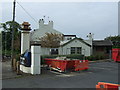
Four Topped Oak Inn, Widnes
Due to reopen shortly after refurbishment (Sept. 2014).
Image: © JThomas
Taken: 13 Sep 2014
0.22 miles
5
The Four Topped Oak on Prescot Road, Upton
Image: © Raymond Knapman
Taken: 22 Sep 2012
0.22 miles
6
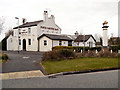
Four Topped Oak
Public house at the junction of Prescot Road and Hough Green Road.
Image: © David Dixon
Taken: 23 Apr 2013
0.22 miles