IMAGES TAKEN NEAR TO
Lower Road, WIDNES, WA8 8NS
Introduction
This page details the photographs taken nearby to Lower Road, WA8 8NS by members of the Geograph project.
The Geograph project started in 2005 with the aim of publishing, organising and preserving representative images for every square kilometre of Great Britain, Ireland and the Isle of Man.

There are currently over 7.5m images from over14,400 individuals and you can help contribute to the project by visiting https://www.geograph.org.uk
Image Map
Images are licensed for reuse under creativecommons.org/licenses/by-sa/2.0
Notes
- Clicking on the map will re-center to the selected point.
- The higher the marker number, the further away the image location is from the centre of the postcode.
Image Listing (5 Images Found)
Images are licensed for reuse under creativecommons.org/licenses/by-sa/2.0
Image
Details
Distance
1

Chemical Works, Lower Road
Just within the Knowsley boundary, this is more typical of the factories and plants in Ditton a mile away.
Image: © Sue Adair
Taken: 20 Aug 2005
0.01 miles
5
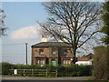
Brook House Farm, Halewood.
Brook House on the sharp bend in Lower Road almost under Speke Boulevard (A562). A typical 19th century farmhouse, it no doubt gets its name from Ditton Brook which runs behind the property. An important Iron Age farmstead, which radiocarbon dating shows was in use between c400-50 BC, was excavated here prior to the construction of the A5300 link road. The site had been damaged during construction of the A562. See link to Liverpool Museum website:-
http://www.liverpoolmuseums.org.uk/mol/archaeology/field/projects/ironage/brook_house_farm.aspx
Image: © Sue Adair
Taken: 12 Apr 2009
0.19 miles