IMAGES TAKEN NEAR TO
Halegate Road, WIDNES, WA8 8LU
Introduction
This page details the photographs taken nearby to Halegate Road, WA8 8LU by members of the Geograph project.
The Geograph project started in 2005 with the aim of publishing, organising and preserving representative images for every square kilometre of Great Britain, Ireland and the Isle of Man.

There are currently over 7.5m images from over14,400 individuals and you can help contribute to the project by visiting https://www.geograph.org.uk
Image Map
Images are licensed for reuse under creativecommons.org/licenses/by-sa/2.0
Notes
- Clicking on the map will re-center to the selected point.
- The higher the marker number, the further away the image location is from the centre of the postcode.
Image Listing (15 Images Found)
Images are licensed for reuse under creativecommons.org/licenses/by-sa/2.0
Image
Details
Distance
1
Hale Gate Road
Looking towards Hale Gate Farm.
Image: © David Dixon
Taken: 17 Apr 2017
0.03 miles

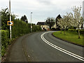
5
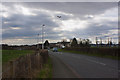
A bend in Hale Road
Above a plane on its landing approach to Liverpool Airport
Image: © Ian Greig
Taken: 16 Mar 2012
0.07 miles
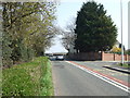
7
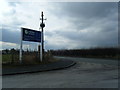
United Utilities entrance on Hale Gate Road.
Image: © Colin Pyle
Taken: 22 Feb 2010
0.20 miles
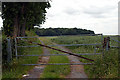
8
Trans Pennine Trail/National Cycle Network Route 62
Also a private access road for the United Utilities Widnes Wastewater Treatment Plant.
Image: © David Dixon
Taken: 17 Apr 2017
0.20 miles
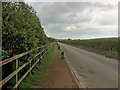
9
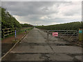
Gated Drive to Widnes Wastewater Treatment Plant
As well as providing vehicular access to the United Utilities sewage works, this private road also serves as part of the Trans Pennine Trail and National Cycle Route 62.
Image: © David Dixon
Taken: 17 Apr 2017
0.21 miles