IMAGES TAKEN NEAR TO
Elizabeth Court, WIDNES, WA8 7YA
Introduction
This page details the photographs taken nearby to Elizabeth Court, WA8 7YA by members of the Geograph project.
The Geograph project started in 2005 with the aim of publishing, organising and preserving representative images for every square kilometre of Great Britain, Ireland and the Isle of Man.

There are currently over 7.5m images from over14,400 individuals and you can help contribute to the project by visiting https://www.geograph.org.uk
Image Map
Images are licensed for reuse under creativecommons.org/licenses/by-sa/2.0
Notes
- Clicking on the map will re-center to the selected point.
- The higher the marker number, the further away the image location is from the centre of the postcode.
Image Listing (32 Images Found)
Images are licensed for reuse under creativecommons.org/licenses/by-sa/2.0
Image
Details
Distance
1
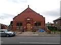
Widnes Community Support Centre
Originally opened in 1899 as the town's Poor Relief Hall, after renovation it was reopened in 1990 as the Widnes Community Support Centre. There seems no indication what the present work is turning it into.
Image: © John Lord
Taken: 17 Aug 2015
0.04 miles
2
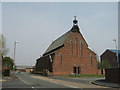
St Marie's RC Church, Lugsdale Road, Widnes
St Marie's RC Church in Lugsdale Road, Widnes is of such special architectural interest, it was listed as a Grade II building by the Secretary of State, weeks before it faced the bulldozers in 2006. The Victoria Society campaigns to save Victorian and Edwardian buildings of architectural importance and the Pugin-designed church has been placed on a national list of 10 endangered buildings.
Image: © Sue Adair
Taken: 21 Apr 2007
0.08 miles
3
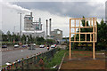
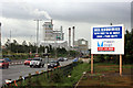
Roadside hoarding by A557, Widnes
A new hoarding frame no doubt ready to announce an impending retail development [on the former foundry site on which it stands] to the public passing on the A557 Widnes Eastern by-pass.
In the distance, the Ditton Junction - Warrington Arpley railway bridge which carries coal trains to and from Fiddler's Ferry power station. The by-pass road is along the course of the Widnes - St Helens railway line which would have passed under the Warrington line where the road does today.
The factory in the background [actually just outside the grid square] belongs to Thermphos International B.V. and produces "speciality phosphates" of the highest order.
Image: © Chris Palmer
Taken: 26 May 2007
0.11 miles
5
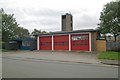
Widnes fire station
Widnes fire station, Lacey Street, Widnes, Cheshire.
Image: © Kevin Hale
Taken: 22 Oct 2006
0.13 miles
7
Roadside hoarding near A557, Widnes
As mentioned earlier (Image) development is nigh, but the purpose of the unit has yet to be revealed
Image: © Chris Palmer
Taken: 4 Jul 2007
0.14 miles
8
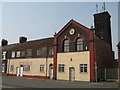
The Old Fire Station, Widnes
The former fire station dated 1891 in Lacey Street, Widnes.
Image: © Sue Adair
Taken: 21 Apr 2007
0.15 miles
9
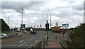
No go! Junction of the A562 and the A557, Runcorn-Widnes bridge approach
The barge BARMERE is on the lorry at the far set of lights, on the last leg of her journey to Spike Island.
Image: © David Long
Taken: 13 Oct 2005
0.15 miles
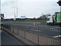
10

The A557 runs under a railway bridge
Image: © Steve Daniels
Taken: 29 Aug 2014
0.15 miles