IMAGES TAKEN NEAR TO
Lilac Avenue, WIDNES, WA8 6SX
Introduction
This page details the photographs taken nearby to Lilac Avenue, WA8 6SX by members of the Geograph project.
The Geograph project started in 2005 with the aim of publishing, organising and preserving representative images for every square kilometre of Great Britain, Ireland and the Isle of Man.

There are currently over 7.5m images from over14,400 individuals and you can help contribute to the project by visiting https://www.geograph.org.uk
Image Map (Loading...)


Getting Data...Please wait
Leaflet Map data © OpenStreetMap
Images are licensed for reuse under creativecommons.org/licenses/by-sa/2.0
Notes
- Clicking on the map will re-center to the selected point.
- The higher the marker number, the further away the image location is from the centre of the postcode.
Image Listing (5 Images Found)
Images are licensed for reuse under creativecommons.org/licenses/by-sa/2.0
Image
Details
Distance
1
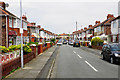
Fairhaven Road
A residential street with typical suburban semis.
Image: © Bill Boaden
Taken: 22 May 2017
0.17 miles
2
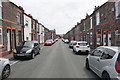
Allerton Road
One of a series of long parallel terraced streets.
Image: © Bill Boaden
Taken: 22 May 2017
0.20 miles
3
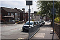
Peel House Lane from the end of Mount Pleasant
Image: © Ian Greig
Taken: 19 Aug 2011
0.21 miles
4
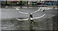
Chase Me
Swans having a flyabout on the small lake at Victoria Park
Image: © Alan James
Taken: 10 Apr 2010
0.21 miles
5
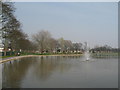
Victoria Park Lake
The new boating lake and fountain in Victoria Park, Appleton, Widnes. The park is in the middle of a major refurbishment with money from the Lottery Fund.
Image: © Sue Adair
Taken: 27 Mar 2007
0.23 miles