IMAGES TAKEN NEAR TO
Penny Lane, WIDNES, WA8 5PT
Introduction
This page details the photographs taken nearby to Penny Lane, WA8 5PT by members of the Geograph project.
The Geograph project started in 2005 with the aim of publishing, organising and preserving representative images for every square kilometre of Great Britain, Ireland and the Isle of Man.

There are currently over 7.5m images from over14,400 individuals and you can help contribute to the project by visiting https://www.geograph.org.uk
Image Map
Images are licensed for reuse under creativecommons.org/licenses/by-sa/2.0
Notes
- Clicking on the map will re-center to the selected point.
- The higher the marker number, the further away the image location is from the centre of the postcode.
Image Listing (3 Images Found)
Images are licensed for reuse under creativecommons.org/licenses/by-sa/2.0
Image
Details
Distance
3
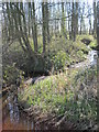
Brook through Rough Head Wood
One of the many narrow unnamed brooks draining the surrounding farmland. These small watercourses drain into Fox's Bank Brook, Logwood Mill Brook, Dog Clog Brook then into Ditton Brook and eventually the River Mersey between Halebank and Ditton.
Image: © Sue Adair
Taken: 28 Mar 2019
0.22 miles