IMAGES TAKEN NEAR TO
Alder Lane, WIDNES, WA8 5PR
Introduction
This page details the photographs taken nearby to Alder Lane, WA8 5PR by members of the Geograph project.
The Geograph project started in 2005 with the aim of publishing, organising and preserving representative images for every square kilometre of Great Britain, Ireland and the Isle of Man.

There are currently over 7.5m images from over14,400 individuals and you can help contribute to the project by visiting https://www.geograph.org.uk
Image Map (Loading...)


Getting Data...Please wait
Leaflet Map data © OpenStreetMap
Images are licensed for reuse under creativecommons.org/licenses/by-sa/2.0
Notes
- Clicking on the map will re-center to the selected point.
- The higher the marker number, the further away the image location is from the centre of the postcode.
Image Listing (8 Images Found)
Images are licensed for reuse under creativecommons.org/licenses/by-sa/2.0
Image
Details
Distance
1
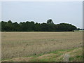
Farmland, Smaller Gorse Farm
North of Alder Lane.
Image: © JThomas
Taken: 13 Sep 2014
0.09 miles
2
Entrance to Smaller Gorse Farm
A farm drive on a cold frosty day.
Image: © Bill Boaden
Taken: 31 Jan 2019
0.11 miles
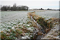
3
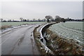
Alder Lane
Passing through flat farmland west of Cronton, with a drainage channel next to it. It is viewed on a cold frosty day.
Image: © Bill Boaden
Taken: 31 Jan 2019
0.12 miles
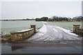
5
Drainage channel near Smaller Gorse Farm
Cronton Farm is straight ahead.
Image: © Bill Boaden
Taken: 31 Jan 2019
0.14 miles
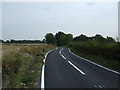
6
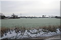
Farmland by Alder Lane
You can see some of the houses of Upton, a suburb of Widnes.
Image: © Bill Boaden
Taken: 31 Jan 2019
0.17 miles
7
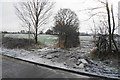
Footpath off Alder Lane
The footpath runs to the left of the hedge and leads towards Upton. It is a cold frosty day.
Image: © Bill Boaden
Taken: 31 Jan 2019
0.18 miles
8
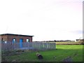
Cronton Booster
Water pumping station at the end of Alder Lane, Cronton. View looking west across Smaller Gorse Farm.
Image: © Roger May
Taken: 16 Dec 2005
0.24 miles