IMAGES TAKEN NEAR TO
Bollin Court, WIDNES, WA8 5EA
Introduction
This page details the photographs taken nearby to Bollin Court, WA8 5EA by members of the Geograph project.
The Geograph project started in 2005 with the aim of publishing, organising and preserving representative images for every square kilometre of Great Britain, Ireland and the Isle of Man.

There are currently over 7.5m images from over14,400 individuals and you can help contribute to the project by visiting https://www.geograph.org.uk
Image Map
Images are licensed for reuse under creativecommons.org/licenses/by-sa/2.0
Notes
- Clicking on the map will re-center to the selected point.
- The higher the marker number, the further away the image location is from the centre of the postcode.
Image Listing (13 Images Found)
Images are licensed for reuse under creativecommons.org/licenses/by-sa/2.0
Image
Details
Distance
1

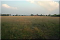
Soggy field on the edge of Lunt's Heath
This is the northern edge of the Widnes conurbation.
Image: © Bill Boaden
Taken: 31 Jan 2019
0.05 miles
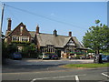
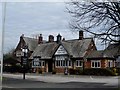
3

Cranshaw Lane
A private road leading to Cranshaw Hall.
Image: © Bill Boaden
Taken: 31 Jan 2019
0.06 miles
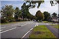
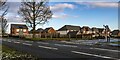
4

Daffodil patch by Lunt's Heath Road
It is still too early for the daffodils to flower. The area is a large housing expansion of Widnes with a broad green verge by the A5080.
Image: © Bill Boaden
Taken: 31 Jan 2019
0.12 miles
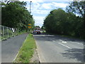
7
Farmer's Field - Lunts Heath near Widnes
This is a view looking ESE across farm land near Lunt Heath, Widnes. Taken while standing at SJ 51248 88586.
Image: © andy
Taken: 5 Sep 2005
0.23 miles
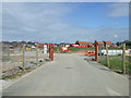
9
Wilmere Lane
New housing development off Wilmere Lane.
Image: © Peter McDermott
Taken: 3 Jan 2021
0.23 miles