IMAGES TAKEN NEAR TO
Nickleford Hall Drive, WIDNES, WA8 5AL
Introduction
This page details the photographs taken nearby to Nickleford Hall Drive, WA8 5AL by members of the Geograph project.
The Geograph project started in 2005 with the aim of publishing, organising and preserving representative images for every square kilometre of Great Britain, Ireland and the Isle of Man.

There are currently over 7.5m images from over14,400 individuals and you can help contribute to the project by visiting https://www.geograph.org.uk
Image Map
Images are licensed for reuse under creativecommons.org/licenses/by-sa/2.0
Notes
- Clicking on the map will re-center to the selected point.
- The higher the marker number, the further away the image location is from the centre of the postcode.
Image Listing (8 Images Found)
Images are licensed for reuse under creativecommons.org/licenses/by-sa/2.0
Image
Details
Distance
1

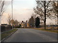
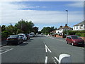
New housing estate on Norlands Lane
Image: © Raymond Knapman
Taken: 31 Aug 2010
0.07 miles
2
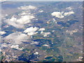
Looking west from above Warrington
The obvious road running up and down the image is the M62 heading for Liverpool; J7, with the A557 and A570, is the lower of the two main junctions. Above it is J6 at centre right, the interchange between the M62, M57 and A5300. The long straight line to the left is the railway from Warrington to Liverpool, and in the distance is the River Mersey.
Image: © M J Richardson
Taken: 3 Jun 2015
0.18 miles

4
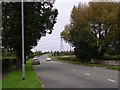
Wilmere Lane
Looking in a northerly direction up Wilmere Lane Widnes. SJ51228878.
Image: © Keith Williamson
Taken: 23 Sep 2005
0.22 miles
5
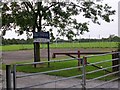
Wilmere Lane Playing Fields
The entrance to these fields at Widnes. SJ51228878.
Image: © Keith Williamson
Taken: 23 Sep 2005
0.22 miles
7
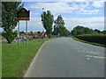
Entering Farnworth
Heading south on Wilmere Lane (B5419).
Image: © JThomas
Taken: 5 Jun 2014
0.24 miles