IMAGES TAKEN NEAR TO
Brookdale, WIDNES, WA8 4TA
Introduction
This page details the photographs taken nearby to Brookdale, WA8 4TA by members of the Geograph project.
The Geograph project started in 2005 with the aim of publishing, organising and preserving representative images for every square kilometre of Great Britain, Ireland and the Isle of Man.

There are currently over 7.5m images from over14,400 individuals and you can help contribute to the project by visiting https://www.geograph.org.uk
Image Map
Images are licensed for reuse under creativecommons.org/licenses/by-sa/2.0
Notes
- Clicking on the map will re-center to the selected point.
- The higher the marker number, the further away the image location is from the centre of the postcode.
Image Listing (20 Images Found)
Images are licensed for reuse under creativecommons.org/licenses/by-sa/2.0
Image
Details
Distance
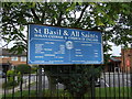
4
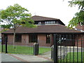
St Basil & All Saints Church on Hough Green Road
Roman Catholic and Church of England Church.
Image: © JThomas
Taken: 13 Sep 2014
0.08 miles
5
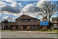
St Basil and All Saints Church
A shared Roman Catholic and Church of England church on Hough Green Road.
Image: © David Dixon
Taken: 12 Mar 2013
0.09 miles
6
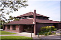
St Basil and All Saints - shared church
1983. Shared building for a joint Church of England and Roman Catholic congregation.
Image: © S Parish
Taken: 11 May 2007
0.10 miles
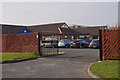
8
Betting shop on Hough Green Road
Conveniently located next door to the public house.
Image: © JThomas
Taken: 13 Sep 2014
0.12 miles
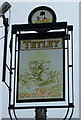
9
The Sporting Ford, Upton
Public house on Hough Green Road.
Image: © David Dixon
Taken: 12 Mar 2013
0.13 miles