IMAGES TAKEN NEAR TO
Clock Face Road, WIDNES, WA8 3XX
Introduction
This page details the photographs taken nearby to Clock Face Road, WA8 3XX by members of the Geograph project.
The Geograph project started in 2005 with the aim of publishing, organising and preserving representative images for every square kilometre of Great Britain, Ireland and the Isle of Man.

There are currently over 7.5m images from over14,400 individuals and you can help contribute to the project by visiting https://www.geograph.org.uk
Image Map
Images are licensed for reuse under creativecommons.org/licenses/by-sa/2.0
Notes
- Clicking on the map will re-center to the selected point.
- The higher the marker number, the further away the image location is from the centre of the postcode.
Image Listing (3 Images Found)
Images are licensed for reuse under creativecommons.org/licenses/by-sa/2.0
Image
Details
Distance
1
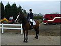
The Bold Equestrian Centre, Bold Nr. St. Helens
This farm now turned into an Equestrian Centre is a very popular place at the weekends for all horsey people. There are indoor and outdoor arenas for all aspects of horse riding and show jumping. A new cross country facility has been built and will attract many would be Harvey Smiths.
Image: © Alan Pennington
Taken: 24 Mar 2002
0.11 miles