IMAGES TAKEN NEAR TO
Finger House Lane, WIDNES, WA8 3XE
Introduction
This page details the photographs taken nearby to Finger House Lane, WA8 3XE by members of the Geograph project.
The Geograph project started in 2005 with the aim of publishing, organising and preserving representative images for every square kilometre of Great Britain, Ireland and the Isle of Man.

There are currently over 7.5m images from over14,400 individuals and you can help contribute to the project by visiting https://www.geograph.org.uk
Image Map
Images are licensed for reuse under creativecommons.org/licenses/by-sa/2.0
Notes
- Clicking on the map will re-center to the selected point.
- The higher the marker number, the further away the image location is from the centre of the postcode.
Image Listing (11 Images Found)
Images are licensed for reuse under creativecommons.org/licenses/by-sa/2.0
Image
Details
Distance
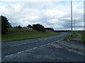
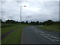
1
Northern end of Tibbs Cross Lane, near the A569
Image: © David Long
Taken: 18 Jan 2010
0.02 miles
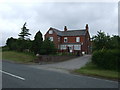
3
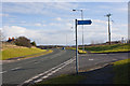
A fingerpost at the end of Finger House Lane
Image: © Ian Greig
Taken: 18 Feb 2012
0.04 miles
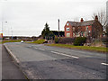
4
Tibbs Cross Lane/Clock Face Road junction
Image: © Colin Pyle
Taken: 7 Aug 2010
0.06 miles
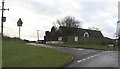
7
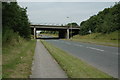
M62 crossing A569
This is the M62 crossing the A569, Clockface Road, just south of Clockface, St.Helens.
Image: © andy
Taken: 17 Jul 2005
0.15 miles
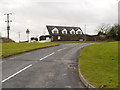
9
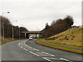
Motorway Bridge, Clock Face Road
The M62 motorway crossing above Clock Face Road (A569).
Image: © David Dixon
Taken: 8 Feb 2013
0.16 miles
10
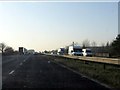
M62 motorway about to cross Clock Face Road
Image: © Peter Whatley
Taken: 17 Jan 2012
0.17 miles