IMAGES TAKEN NEAR TO
Clock Face Road, WIDNES, WA8 3UY
Introduction
This page details the photographs taken nearby to Clock Face Road, WA8 3UY by members of the Geograph project.
The Geograph project started in 2005 with the aim of publishing, organising and preserving representative images for every square kilometre of Great Britain, Ireland and the Isle of Man.

There are currently over 7.5m images from over14,400 individuals and you can help contribute to the project by visiting https://www.geograph.org.uk
Image Map
Images are licensed for reuse under creativecommons.org/licenses/by-sa/2.0
Notes
- Clicking on the map will re-center to the selected point.
- The higher the marker number, the further away the image location is from the centre of the postcode.
Image Listing (13 Images Found)
Images are licensed for reuse under creativecommons.org/licenses/by-sa/2.0
Image
Details
Distance
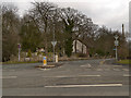
1
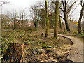
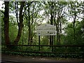
School Lane Wood
Small patch of woodland off School Lane at Bold Heath.
Image: © David Dixon
Taken: 8 Feb 2013
0.03 miles
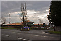
3
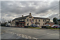
Bold Heath, The Griffin
Pub/restaurant on the A57, Warrington Road, at Bold Heath.
Image: © David Dixon
Taken: 8 Feb 2013
0.11 miles
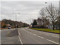
4
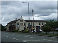
The Griffin pub, Bold Heath
On Warrington Road.
Image: © JThomas
Taken: 5 Jun 2014
0.11 miles
5
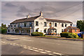
The Griffin Inn, Bold Heath
Chef and Brewer pub/restaurant/carvery on Warrington Road at Bold Heath.
Image: © David Dixon
Taken: 6 Jul 2019
0.11 miles
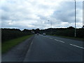
7
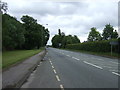
Warrington Road (A57), Bold Heath
Heading east.
Image: © JThomas
Taken: 5 Jun 2014
0.12 miles