IMAGES TAKEN NEAR TO
Twyford Lane, WIDNES, WA8 3UR
Introduction
This page details the photographs taken nearby to Twyford Lane, WA8 3UR by members of the Geograph project.
The Geograph project started in 2005 with the aim of publishing, organising and preserving representative images for every square kilometre of Great Britain, Ireland and the Isle of Man.

There are currently over 7.5m images from over14,400 individuals and you can help contribute to the project by visiting https://www.geograph.org.uk
Image Map
Images are licensed for reuse under creativecommons.org/licenses/by-sa/2.0
Notes
- Clicking on the map will re-center to the selected point.
- The higher the marker number, the further away the image location is from the centre of the postcode.
Image Listing (9 Images Found)
Images are licensed for reuse under creativecommons.org/licenses/by-sa/2.0
Image
Details
Distance
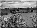
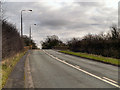
2
Crossroads along Warrington Road nr Rainhill
Crossroads along Warrington Road (A57) at the junction with Tibbs Cross Lane (on the left) and Twyford Lane (on the right). Near Rainhill.
Image: © andy
Taken: 26 Jun 2005
0.07 miles
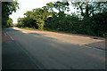
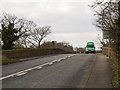
3
Southern end of Tibbs Cross Lane, junction with the A57
Image: © David Long
Taken: 18 Jan 2010
0.09 miles
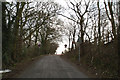
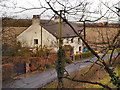
4
Tibbs Cross Lane
Looking down Tibbs Cross Lane towards Bold Bridge Cottages.
Image: © David Dixon
Taken: 8 Feb 2013
0.10 miles
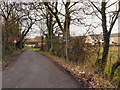
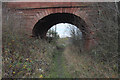
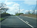
7
Bold Bridge
Warrington Road (A57) crossing over the now dismantled line of the former LMS railway at Bold Bridge.
Image: © David Dixon
Taken: 8 Feb 2013
0.14 miles
8
Bold Railway Bridge
Disused railway bridge plans are submitted to turn the old railway route into a walking and cycle track possibly a bridleway
Image: © Alan James
Taken: 10 Dec 2013
0.14 miles
9
Warrington Road crosses disused St Helens railway
Image: © Colin Pyle
Taken: 24 Apr 2012
0.14 miles