IMAGES TAKEN NEAR TO
South Lane, WIDNES, WA8 3TY
Introduction
This page details the photographs taken nearby to South Lane, WA8 3TY by members of the Geograph project.
The Geograph project started in 2005 with the aim of publishing, organising and preserving representative images for every square kilometre of Great Britain, Ireland and the Isle of Man.

There are currently over 7.5m images from over14,400 individuals and you can help contribute to the project by visiting https://www.geograph.org.uk
Image Map
Images are licensed for reuse under creativecommons.org/licenses/by-sa/2.0
Notes
- Clicking on the map will re-center to the selected point.
- The higher the marker number, the further away the image location is from the centre of the postcode.
Image Listing (6 Images Found)
Images are licensed for reuse under creativecommons.org/licenses/by-sa/2.0
Image
Details
Distance
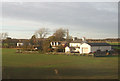
1
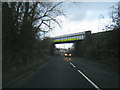
Farnworth Road passing under Liverpool to Warrington railway line
Image: © Colin Pyle
Taken: 21 Jan 2012
0.05 miles
4
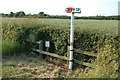
High Pressure Pipeline Marker
This is a High Pressure Pipeline marker along Sandy Lane, Penketh (I think). Not much else along this lonely road...
Image: © andy
Taken: 26 Jun 2005
0.12 miles
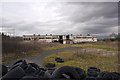
6
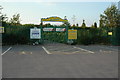
White Moss Garden Centre
White Moss "The Nursery" Garden Centre on South Lane (A5080) between Farnworth and Penketh.
Image: © andy
Taken: 26 Jun 2005
0.20 miles