IMAGES TAKEN NEAR TO
Kew Gardens Close, WIDNES, WA8 3BF
Introduction
This page details the photographs taken nearby to Kew Gardens Close, WA8 3BF by members of the Geograph project.
The Geograph project started in 2005 with the aim of publishing, organising and preserving representative images for every square kilometre of Great Britain, Ireland and the Isle of Man.

There are currently over 7.5m images from over14,400 individuals and you can help contribute to the project by visiting https://www.geograph.org.uk
Image Map
Images are licensed for reuse under creativecommons.org/licenses/by-sa/2.0
Notes
- Clicking on the map will re-center to the selected point.
- The higher the marker number, the further away the image location is from the centre of the postcode.
Image Listing (18 Images Found)
Images are licensed for reuse under creativecommons.org/licenses/by-sa/2.0
Image
Details
Distance
4
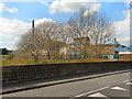
Rockwood Chemical Works, Moorfield Road
Looking over the railway bridge, towards the Rockwood Chemical Plant on Moorfield Road.
Image: © David Dixon
Taken: 20 Apr 2013
0.15 miles
5
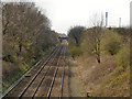
Railway (W) at Barrow's Green
Looking west, towards Liverpool, from the bridge at Barrow's Green Lane.
Image: © David Dixon
Taken: 20 Apr 2013
0.16 miles
6
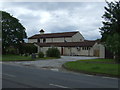
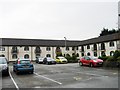
The Evergalades Park Hotel
Best Western on Derby Road.
Image: © JThomas
Taken: 5 Jun 2014
0.16 miles