IMAGES TAKEN NEAR TO
Carter House Way, WIDNES, WA8 0WR
Introduction
This page details the photographs taken nearby to Carter House Way, WA8 0WR by members of the Geograph project.
The Geograph project started in 2005 with the aim of publishing, organising and preserving representative images for every square kilometre of Great Britain, Ireland and the Isle of Man.

There are currently over 7.5m images from over14,400 individuals and you can help contribute to the project by visiting https://www.geograph.org.uk
Image Map
Images are licensed for reuse under creativecommons.org/licenses/by-sa/2.0
Notes
- Clicking on the map will re-center to the selected point.
- The higher the marker number, the further away the image location is from the centre of the postcode.
Image Listing (31 Images Found)
Images are licensed for reuse under creativecommons.org/licenses/by-sa/2.0
Image
Details
Distance
1
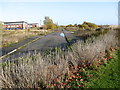
Industrial wasteland awaiting redevelopment
Off Earle Road. This whole area is part of the Widness Waterfront Regeneration programme. There are new office units on the left and in the distance is the Fiddlers Ferry Power Station.
Image: © Maggie Cox
Taken: 14 Nov 2013
0.02 miles
2
The diverted Transpennine Trail
The diversion applies while the Mersey Gateway is being built, but the path will no doubt continue as a walking and cycling route. It is crossing former industrial land.
Image: © Bill Boaden
Taken: 22 May 2017
0.03 miles
3
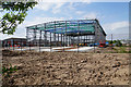
New industrial unit under construction
A former industrial site is being revitalised.
Image: © Bill Boaden
Taken: 22 May 2017
0.08 miles
4
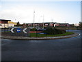
Earle Road roundabout
With new office units in the background.
Image: © Maggie Cox
Taken: 14 Nov 2013
0.10 miles
5
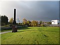
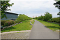
Open leisure area
Created in part of the Widnes Waterfront Regeneration Programme off Earle Road. A greenway/cycle path is on the left. In the distance on the left are the Therm Phos Works and on the right is The Premier Inn.
Image: © Maggie Cox
Taken: 14 Nov 2013
0.11 miles
6
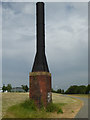
Old stack - Widnes
I presume this may be related to the former chemical industry or be possibly a sewer vent. There is a listed brick sewer vent elsewhere in Widnes. I would welcome any further information. I have been unable to find anything further on the internet.
Image: © Chris Allen
Taken: 9 Jun 2018
0.11 miles
7
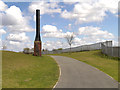
Landscaped path, Widnes Waterfront
The Widnes Waterfront Regeneration Programme was developed to transform over 300 acres of former chemical works on the north bank of the River Mersey into a mixed use area, providing a place for businesses to locate and for people to enjoy. The programme began in 2002 using European and UK Government funding and has since attracted further private sector investment.
To the left of the path, is a preserved reminder of the industrial past; possibly connected with the kilns which were used to burn pyrites in the manufacture of sulphuric acid?
Image: © David Dixon
Taken: 26 Apr 2013
0.13 miles
8
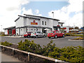
The Buffet Place
Carvery restaurant on the corner of The Hive leisure complex at Widnes.
Image: © David Dixon
Taken: 26 Apr 2013
0.14 miles
9
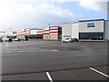
The new Hive Leisure Park
Off Earle Road. This is part of the Widnes Waterfront Regeneration Programme
Image: © Maggie Cox
Taken: 14 Nov 2013
0.15 miles
10
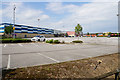
The Hive Leisure Park
A fairly new complex built on former brownfield land on Widnes Waterfront.
Image: © Bill Boaden
Taken: 22 May 2017
0.15 miles