IMAGES TAKEN NEAR TO
Bennetts Lane, WIDNES, WA8 0WB
Introduction
This page details the photographs taken nearby to Bennetts Lane, WA8 0WB by members of the Geograph project.
The Geograph project started in 2005 with the aim of publishing, organising and preserving representative images for every square kilometre of Great Britain, Ireland and the Isle of Man.

There are currently over 7.5m images from over14,400 individuals and you can help contribute to the project by visiting https://www.geograph.org.uk
Image Map
Images are licensed for reuse under creativecommons.org/licenses/by-sa/2.0
Notes
- Clicking on the map will re-center to the selected point.
- The higher the marker number, the further away the image location is from the centre of the postcode.
Image Listing (3 Images Found)
Images are licensed for reuse under creativecommons.org/licenses/by-sa/2.0
Image
Details
Distance
1
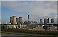
New development on Bennetts Lane
Industry is continuing to develop here on the eastern side of Widnes. Fiddlers Ferry Power Station dominates.
Image: © Alan Murray-Rust
Taken: 6 Oct 2008
0.11 miles
3
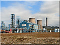
Chemical Plant, Widnes
This is a view taken from SJ 53328 86484 looking east at one of the many chemical plants around Widnes. This particular one belongs to Aroma & Fine Chemical (part of the Octel Corp). In the background can be seen a rather imposing Fiddlers Ferry Power Station which is in the next grid square to the east.
Image: © andy
Taken: 5 Sep 2005
0.23 miles