IMAGES TAKEN NEAR TO
Caravan Park, Tanhouse Lane, WIDNES, WA8 0SP
Introduction
This page details the photographs taken nearby to Caravan Park, Tanhouse Lane, WA8 0SP by members of the Geograph project.
The Geograph project started in 2005 with the aim of publishing, organising and preserving representative images for every square kilometre of Great Britain, Ireland and the Isle of Man.

There are currently over 7.5m images from over14,400 individuals and you can help contribute to the project by visiting https://www.geograph.org.uk
Image Map
Images are licensed for reuse under creativecommons.org/licenses/by-sa/2.0
Notes
- Clicking on the map will re-center to the selected point.
- The higher the marker number, the further away the image location is from the centre of the postcode.
Image Listing (6 Images Found)
Images are licensed for reuse under creativecommons.org/licenses/by-sa/2.0
Image
Details
Distance
3
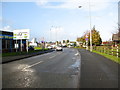
Approaching a busy road junction
On Earle Road where it meets the A557
Image: © Maggie Cox
Taken: 14 Nov 2013
0.17 miles
5
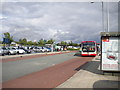
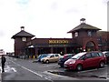
Green Oaks bus interchange, Widnes
In contrast to Vicarage Road (see Image), Green Oaks is Widnes' busier bus interchange, in terms of both buses and people. It is effectively a road through the shopping centre car park, visible over the road from the photographer.
Image: © Richard Vince
Taken: 28 Jul 2012
0.24 miles
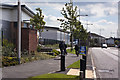
6
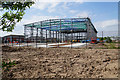
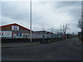
New industrial unit under construction
A former industrial site is being revitalised.
Image: © Bill Boaden
Taken: 22 May 2017
0.25 miles