IMAGES TAKEN NEAR TO
Hutchinson Street, WIDNES, WA8 0PZ
Introduction
This page details the photographs taken nearby to Hutchinson Street, WA8 0PZ by members of the Geograph project.
The Geograph project started in 2005 with the aim of publishing, organising and preserving representative images for every square kilometre of Great Britain, Ireland and the Isle of Man.

There are currently over 7.5m images from over14,400 individuals and you can help contribute to the project by visiting https://www.geograph.org.uk
Image Map
Images are licensed for reuse under creativecommons.org/licenses/by-sa/2.0
Notes
- Clicking on the map will re-center to the selected point.
- The higher the marker number, the further away the image location is from the centre of the postcode.
Image Listing (63 Images Found)
Images are licensed for reuse under creativecommons.org/licenses/by-sa/2.0
Image
Details
Distance
1
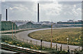
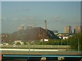
Chemical Plant at Widnes
SE view from road approaching Widnes - Runcorn Bridge; Halton Hill on horizon.
Image: © Ben Brooksbank
Taken: 20 Aug 1963
0.07 miles
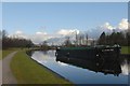
3
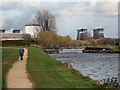
Sankey (St Helens) Canal, Spike Island
A chemical works and the cooling towers of Fiddler's Ferry power station dominate the skyline.
Image: © David Dixon
Taken: 26 Apr 2013
0.09 miles
6
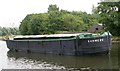
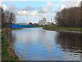
Mersey Flat "Barmere" moored on Sankey Canal
Image: © Betty Longbottom
Taken: 14 Aug 2007
0.09 miles
7
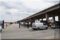
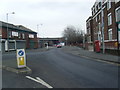
New flyover for the Mersey Gateway
Still under construction.
Image: © Bill Boaden
Taken: 22 May 2017
0.09 miles